IMAGES TAKEN NEAR TO
St. Marys Road, CWMBRAN, NP44 2EL
Introduction
This page details the photographs taken nearby to St. Marys Road, NP44 2EL by members of the Geograph project.
The Geograph project started in 2005 with the aim of publishing, organising and preserving representative images for every square kilometre of Great Britain, Ireland and the Isle of Man.

There are currently over 7.5m images from over14,400 individuals and you can help contribute to the project by visiting https://www.geograph.org.uk
Image Map
Images are licensed for reuse under creativecommons.org/licenses/by-sa/2.0
Notes
- Clicking on the map will re-center to the selected point.
- The higher the marker number, the further away the image location is from the centre of the postcode.
Image Listing (208 Images Found)
Images are licensed for reuse under creativecommons.org/licenses/by-sa/2.0
Image
Details
Distance
1
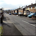
Bryn Garw, Croesyceiliog, Cwmbran
Frem the corner of North Road.
Image: © Jaggery
Taken: 15 Feb 2015
0.02 miles
2
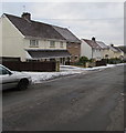
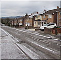
Dusting of snow, Bryn Eglwys, Croesyceiliog, Cwmbran
Patchy snow on roofs and pavements on February 28th 2018, the last day of meteorological Winter. Much heavier, possibly disruptive, snow is forecast for this area tomorrow, St David's Day, the first day of meteorological Spring.
Image: © Jaggery
Taken: 28 Feb 2018
0.04 miles
3
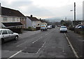
Bryn Eglwys WSW of North Road, Croesyceiliog, Cwmbran
Image: © Jaggery
Taken: 15 Feb 2015
0.04 miles
4
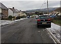
Down Bryn Eglwys, Croesyceiliog, Cwmbran
The road named Bryn Eglwys descends from North Road.
Image: © Jaggery
Taken: 28 Feb 2018
0.04 miles
5
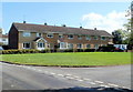
Bryn Garw houses, Croesyceiliog, Cwmbran
A row of houses in Bryn Garw, a residential road near St Mary's Church. http://www.geograph.org.uk/photo/2598964
Image: © Jaggery
Taken: 13 Sep 2011
0.05 miles
6
Rooftop solar panels, Bryn Garw, Croesyceiliog, Cwmbran
Viewed from the corner of North Road in February 2018.
A June 2011 Google Earth Street View shows no panels here.
Image: © Jaggery
Taken: 28 Feb 2018
0.05 miles
7
Corner of Bryn Eglwys and St Mary's Road, Croesyceiliog, Cwmbran
Viewed across Bryn Eglwys. Turn right here into St Mary's Road for St Mary's church.
Image: © Jaggery
Taken: 13 Sep 2011
0.05 miles
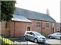
8
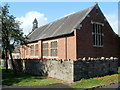
SE side of St Mary's Church, Croesyceiliog, Cwmbran
The Church in Wales church is located on St Mary's Road, Croesyceiliog.
http://www.geograph.org.uk/photo/2598971 to a view from the opposite direction.
Image: © Jaggery
Taken: 13 Sep 2011
0.07 miles
9
NW side of St Mary's Church, Croesyceiliog, Cwmbran
The Church in Wales church is located on St Mary's Road, Croesyceiliog.
http://www.geograph.org.uk/photo/2598964 to a view from the opposite side.
Image: © Jaggery
Taken: 13 Sep 2011
0.07 miles
10
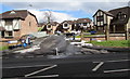
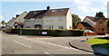
Woodland View, Croesyceiliog, Cwmbran
Cul-de-sac of eight houses built in 2001 viewed across Woodland Road.
Image: © Jaggery
Taken: 7 Mar 2018
0.07 miles