IMAGES TAKEN NEAR TO
Croesyceiliog, CWMBRAN, NP44 2DE
Introduction
This page details the photographs taken nearby to NP44 2DE by members of the Geograph project.
The Geograph project started in 2005 with the aim of publishing, organising and preserving representative images for every square kilometre of Great Britain, Ireland and the Isle of Man.

There are currently over 7.5m images from over14,400 individuals and you can help contribute to the project by visiting https://www.geograph.org.uk
Image Map
Images are licensed for reuse under creativecommons.org/licenses/by-sa/2.0
Notes
- Clicking on the map will re-center to the selected point.
- The higher the marker number, the further away the image location is from the centre of the postcode.
Image Listing (23 Images Found)
Images are licensed for reuse under creativecommons.org/licenses/by-sa/2.0
Image
Details
Distance
1
Roadside safety mirror, Tre-herbert Road west of Llanddewi Fach
The mirror on top of a hedge is located opposite the exit from a house on the left,
which is at right angles to Tre-herbert Road near a bend.
Image: © Jaggery
Taken: 27 Sep 2011
0.03 miles
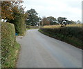
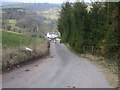
2
Right turn for Perthellic Farm west of Llanddewi Fach
Viewed from Tre-Herbert Road. The 400-metre long access road leads to Perthellic Farm.
Image: © Jaggery
Taken: 27 Sep 2011
0.08 miles
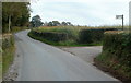
4
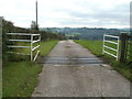
Cattle grid across the access road to Perthellic Farm west of Llanddewi Fach
Viewed from Tre-herbert Road. The farm buildings are about 400 metres ahead, out of shot.
Image: © Jaggery
Taken: 27 Sep 2011
0.09 miles
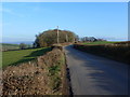
6
Old railway wagon used for storage, Glebe Farm west of Llanddewi Fach
The shed is one of probably thousands of former railway wagon bodies,
now used for static storage, to be seen in many parts of the UK.
Image: © Jaggery
Taken: 27 Sep 2011
0.13 miles
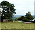
8

Tree in an arable field, south of Granary Farm
A faintly discernible public footpath crosses in front of the tree.
Image: © Christine Johnstone
Taken: 16 Sep 2013
0.16 miles
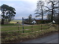
9
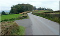
Tre-herbert Road passes the turning for Granary Farm
The left turn is for the access lane http://www.geograph.org.uk/photo/2622448 to Granary Farm.
Image: © Jaggery
Taken: 27 Sep 2011
0.17 miles
10
Sealed-up disused postbox, Tre-herbert Road west of Llanddewi Fach
The former postbox is in a wall outside The Old Rectory.
Its former covering of red paint has been removed, and its opening sealed up.
A red dot in the distance is the current postbox. http://www.geograph.org.uk/photo/3374188
Image: © Jaggery
Taken: 27 Sep 2011
0.17 miles