IMAGES TAKEN NEAR TO
The Highway, CWMBRAN, NP44 2BG
Introduction
This page details the photographs taken nearby to The Highway, NP44 2BG by members of the Geograph project.
The Geograph project started in 2005 with the aim of publishing, organising and preserving representative images for every square kilometre of Great Britain, Ireland and the Isle of Man.

There are currently over 7.5m images from over14,400 individuals and you can help contribute to the project by visiting https://www.geograph.org.uk
Image Map
Images are licensed for reuse under creativecommons.org/licenses/by-sa/2.0
Notes
- Clicking on the map will re-center to the selected point.
- The higher the marker number, the further away the image location is from the centre of the postcode.
Image Listing (106 Images Found)
Images are licensed for reuse under creativecommons.org/licenses/by-sa/2.0
Image
Details
Distance
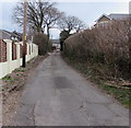
1
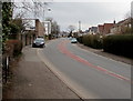
Up The Highway, Croesyceiliog, Cwmbran
The Highway ascends towards the North Road junction.
Image: © Jaggery
Taken: 27 Feb 2018
0.02 miles
2
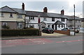
Row of houses alongside The Highway, Croesyceiliog, Cwmbran
South of the North Road junction.
Image: © Jaggery
Taken: 27 Feb 2018
0.03 miles
3
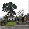
Entrance House, Croesyceiliog, Cwmbran
Viewed across The Highway. When I saw the unusual name ENTRANCE HOUSE on the gate on the right,
I thought there would be a wealth of online information giving the name's origin. Wrong!
As I wrote this description, I remembered that as a verb, 'entrance' means to affect with delight or wonder and seemingly put into a trance, so maybe the namer of the house was referring to its allure...
Image: © Jaggery
Taken: 15 Feb 2015
0.03 miles
4
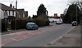
Bend in The Highway, Croesyceiliog, Cwmbran
On the descent towards Woodland Road and Turnpike Road.
Image: © Jaggery
Taken: 27 Feb 2018
0.04 miles
5
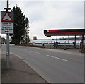
Warning sign - humps for 700 yards, The Highway, Croesyceiliog, Cwmbran
The sign warns of humps along Woodland Road. The text is also in Welsh.
A fenced-off former Texaco filling station is on the right. https://www.geograph.org.uk/photo/5710149
Image: © Jaggery
Taken: 27 Feb 2018
0.04 miles
6

Two Bron Afon vans parked near Bron-y-garth, Croesyceiliog, Cwmbran
Bron-y-garth is a small block of flats on the corner of North Road and The Highway, one of many properties owned by Bron Afon Community Housing, the landlord which was set up specifically to own, manage and improve the housing previously owned by Torfaen County Borough Council.
Image: © Jaggery
Taken: 27 Feb 2018
0.04 miles
7
Jim Crow Square name sign, Croesyceiliog, Cwmbran
https://www.geograph.org.uk/photo/5693801 to a closer view of the bilingual name sign alongside The Highway.
Jim Crow's cottage http://www.geograph.org.uk/photo/2133217 and Jim Crow's Wood are nearby.
Image: © Jaggery
Taken: 15 Feb 2015
0.04 miles
8
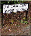
Jim Crow Square name sign, Croesyceiliog, Cwmbran
Located here. http://www.geograph.org.uk/photo/4350190 Jim Crow Square is Sgwâr Jim Crow in Welsh.
Image: © Jaggery
Taken: 27 Feb 2018
0.04 miles
9
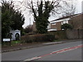
Bron-y-Garth, Croesyceiliog, Cwmbran
Small block of flats viewed across The Highway.
Image: © Jaggery
Taken: 15 Feb 2015
0.04 miles
10
Side road in Croesyceiliog, Cwmbran
On the northeast side of Woodland Road.
Image: © Jaggery
Taken: 27 Feb 2018
0.04 miles