IMAGES TAKEN NEAR TO
Croesyceiliog, CWMBRAN, NP44 2AP
Introduction
This page details the photographs taken nearby to NP44 2AP by members of the Geograph project.
The Geograph project started in 2005 with the aim of publishing, organising and preserving representative images for every square kilometre of Great Britain, Ireland and the Isle of Man.

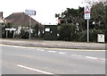
There are currently over 7.5m images from over14,400 individuals and you can help contribute to the project by visiting https://www.geograph.org.uk
Image Map
Images are licensed for reuse under creativecommons.org/licenses/by-sa/2.0
Notes
- Clicking on the map will re-center to the selected point.
- The higher the marker number, the further away the image location is from the centre of the postcode.
Image Listing (85 Images Found)
Images are licensed for reuse under creativecommons.org/licenses/by-sa/2.0
Image
Details
Distance
1
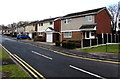
Plantation Drive houses in Croesyceiliog, Cwmbran
Viewed from Turnpike Road. The back gardens of these houses are at the edge of a wood named The Plantation.
Image: © Jaggery
Taken: 15 Feb 2015
0.05 miles
2
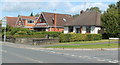
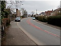
Turnpike Road houses near the corner of Plantation Drive, Croesyceiliog, Cwmbran
Viewed across Turnpike Road.
Image: © Jaggery
Taken: 13 Sep 2011
0.08 miles
3
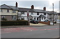
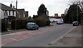
Row of houses alongside The Highway, Croesyceiliog, Cwmbran
South of the North Road junction.
Image: © Jaggery
Taken: 27 Feb 2018
0.08 miles
4
Virgin Media telecoms cabinet, Turnpike Road, Croesyceiliog, Cwmbran
The number 20 is on the front and side of the dark green cabinet.
Image: © Jaggery
Taken: 27 Feb 2018
0.09 miles
5
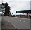
Warning sign - humps for 700 yards, The Highway, Croesyceiliog, Cwmbran
The sign warns of humps along Woodland Road. The text is also in Welsh.
A fenced-off former Texaco filling station is on the right. https://www.geograph.org.uk/photo/5710149
Image: © Jaggery
Taken: 27 Feb 2018
0.09 miles
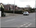
6
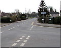
Three-way junction in Croesyceiliog, Cwmbran
The eastern end of Woodland Road on the right is where The Highway on the camera side becomes Turnpike Road ahead.
Image: © Jaggery
Taken: 27 Feb 2018
0.09 miles
7
Up The Highway, Croesyceiliog, Cwmbran
The Highway ascends towards the North Road junction.
Image: © Jaggery
Taken: 27 Feb 2018
0.09 miles
8
Bend in The Highway, Croesyceiliog, Cwmbran
On the descent towards Woodland Road and Turnpike Road.
Image: © Jaggery
Taken: 27 Feb 2018
0.09 miles
9
BT telecoms cabinet on a Croesyceiliog corner, Cwmbran
The dark green cabinet is on the corner of Woodland Road and Turnpike Road.
Image: © Jaggery
Taken: 27 Feb 2018
0.10 miles
10
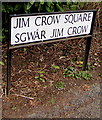
Jim Crow Square name sign, Croesyceiliog, Cwmbran
Located here. http://www.geograph.org.uk/photo/4350190 Jim Crow Square is Sgwâr Jim Crow in Welsh.
Image: © Jaggery
Taken: 27 Feb 2018
0.10 miles