IMAGES TAKEN NEAR TO
Mona Close, CWMBRAN, NP44 1UE
Introduction
This page details the photographs taken nearby to Mona Close, NP44 1UE by members of the Geograph project.
The Geograph project started in 2005 with the aim of publishing, organising and preserving representative images for every square kilometre of Great Britain, Ireland and the Isle of Man.

There are currently over 7.5m images from over14,400 individuals and you can help contribute to the project by visiting https://www.geograph.org.uk
Image Map
Images are licensed for reuse under creativecommons.org/licenses/by-sa/2.0
Notes
- Clicking on the map will re-center to the selected point.
- The higher the marker number, the further away the image location is from the centre of the postcode.
Image Listing (231 Images Found)
Images are licensed for reuse under creativecommons.org/licenses/by-sa/2.0
Image
Details
Distance
1
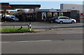
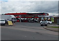
Nisa Local, Avondale Road, Cwmbran
Part of Avondale Service Centre. A Texaco filling station https://www.geograph.org.uk/photo/5626794 is on the left.
Image: © Jaggery
Taken: 30 Oct 2017
0.01 miles
2
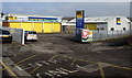
ATS Euromaster Centre, Cwmbran
Located on the north side of Station Road in the Pontnewydd area of Cwmbran, this is one of more than 450 ATS Euromaster Centres in the UK. The business supplies vehicle-related products and services such as tyres, wheel alignment, MoT testing, batteries, brakes, shocks, exhausts and oil change.
Image: © Jaggery
Taken: 12 Dec 2012
0.02 miles
3
ATS Euromaster, Cwmbran
Located on the north side of Station Road, this is one of several hundred ATS Euromaster centres in the UK.
The business supplies vehicle-related products and services such as tyres, wheel alignment, MoT testing, batteries, brakes, shocks, exhausts and oil change.
Image: © Jaggery
Taken: 15 Feb 2015
0.02 miles
4
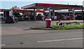
Texaco filling station, Avondale Road, Cwmbran
Part of Avondale Service Station.
Image: © Jaggery
Taken: 30 Oct 2017
0.02 miles
5
Avondale Service Station, Cwmbran
The service station is a Texaco filling station and Nisa Local shop (formerly a Mace shop).
Image: © Jaggery
Taken: 24 May 2013
0.02 miles
6
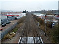
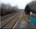
Site of former Lower Pontnewydd railway station, Cwmbran
Viewed from Station Road bridge looking north. A 1940s map shows that Lower Pontnewydd railway station was located here, immediately north of the bridge. Passenger services at Lower Pontnewydd railway station ceased in 1958.
Image: © Jaggery
Taken: 12 Dec 2012
0.03 miles
7
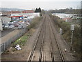
Lower Pontnewydd railway station (site), Gwent
Opened in 1858 by the Pontypool Caerleon & Newport Railway, soon to become part of the Great Western Railway, this station closed to passengers in 1958 and completely in 1965.
View north towards Panteg and Pontypool. No trace appears to remain.
Image: © Nigel Thompson
Taken: 14 Mar 2015
0.04 miles
8
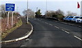
Station Road weight limit sign, Cwmbran
The 7.5 tonnes gross weight limit is a residential area limit in Croesyceiliog, 460 yards ahead. Confusingly for visitors to the area, Station Road does not lead to Cwmbran railway station which is more than 300 metres to the south. This was formerly the road to the now demolished Lower Pontnewydd railway station, where passenger services were withdrawn in 1958.
Image: © Jaggery
Taken: 15 Feb 2015
0.04 miles
9
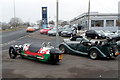
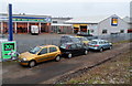
Side view of two Morgan cars parked opposite Newtown Motors, Cwmbran
On the left is Morgan 3-wheeler http://www.geograph.org.uk/photo/3266200 parked next to a Morgan Roadster http://www.geograph.org.uk/photo/3266216
on the pavement at the western end of Somerset Road at the Station Road junction.
Image: © Jaggery
Taken: 12 Dec 2012
0.04 miles
10
Station Road railway bridge viewed from Cwmbran railway station
Confusingly for travellers new to the area, Cwmbran railway station is about 300 metres south of Station Road, which formerly led to Lower Pontnewydd railway station in Cwmbran. Passenger services at that station ended in 1958.
Image: © Jaggery
Taken: 12 Dec 2012
0.05 miles