IMAGES TAKEN NEAR TO
Avondale Road, CWMBRAN, NP44 1UD
Introduction
This page details the photographs taken nearby to Avondale Road, NP44 1UD by members of the Geograph project.
The Geograph project started in 2005 with the aim of publishing, organising and preserving representative images for every square kilometre of Great Britain, Ireland and the Isle of Man.

There are currently over 7.5m images from over14,400 individuals and you can help contribute to the project by visiting https://www.geograph.org.uk
Image Map
Images are licensed for reuse under creativecommons.org/licenses/by-sa/2.0
Notes
- Clicking on the map will re-center to the selected point.
- The higher the marker number, the further away the image location is from the centre of the postcode.
Image Listing (114 Images Found)
Images are licensed for reuse under creativecommons.org/licenses/by-sa/2.0
Image
Details
Distance
1
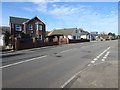
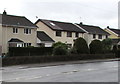
Avondale Road houses, Cwmbran
Houses on the west side of Avondale Road viewed from the corner of Avondale Crescent.
Image: © Jaggery
Taken: 30 Oct 2017
0.04 miles
2
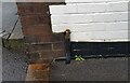
Ordnance Survey Cut Mark
This OS cut mark can be found on No15 Avondale Road. It marks a point 72.759m above mean sea level.
Image: © Adrian Dust
Taken: 16 Feb 2021
0.04 miles
3
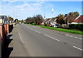
North along Avondale Road, Cwmbran
This way to Pontypool. The Avondale Crescent junction http://www.geograph.org.uk/photo/5584170 is on the right.
Image: © Jaggery
Taken: 30 Oct 2017
0.04 miles
4
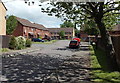
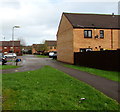
St Andrews Close, Cwmbran
Located in the Pontrhydyrun district at the northern edge of Cwmbran.
Image: © Jaggery
Taken: 24 May 2013
0.05 miles
5
Houses on the south side of Pontrhydyrun Road, Cwmbran
Pontrhydyrun Road extends for 400 metres from Avondale Road (behind the camera) to the A4051 Cwmbran Drive.
Image: © Jaggery
Taken: 6 Mar 2019
0.06 miles
6
Path into St Andrew's Close, Cwmbran
From Avondale Drive.
Image: © Jaggery
Taken: 6 Mar 2019
0.06 miles
7
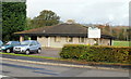
Pontrhydyrun Community Hall, Cwmbran
Located on Pontrhydyrun Road, close to the junction with Avondale Road.
Image: © Jaggery
Taken: 21 Oct 2009
0.07 miles
8
Start of the 30 zone, Pontrhydyrun Road, Cwmbran
The 40mph speed limit on Avondale Road drops to 30mph on Pontrhydyrun Road.
Image: © Jaggery
Taken: 6 Mar 2019
0.07 miles
9
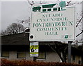
Pontrhydyrun Community Hall bilingual name sign, Cwmbran
The sign shows that this building https://www.geograph.org.uk/photo/6083458 is Neuadd Cymunedol Pontrhydyrun in Welsh.
Image: © Jaggery
Taken: 6 Mar 2019
0.07 miles
10
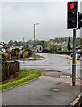
Traffic lights at the western end of Chapel Lane, Cwmbran
At the Avondale Road junction.
Image: © Jaggery
Taken: 30 Apr 2023
0.08 miles