IMAGES TAKEN NEAR TO
Avondale Road, CWMBRAN, NP44 1TT
Introduction
This page details the photographs taken nearby to Avondale Road, NP44 1TT by members of the Geograph project.
The Geograph project started in 2005 with the aim of publishing, organising and preserving representative images for every square kilometre of Great Britain, Ireland and the Isle of Man.

There are currently over 7.5m images from over14,400 individuals and you can help contribute to the project by visiting https://www.geograph.org.uk
Image Map
Images are licensed for reuse under creativecommons.org/licenses/by-sa/2.0
Notes
- Clicking on the map will re-center to the selected point.
- The higher the marker number, the further away the image location is from the centre of the postcode.
Image Listing (218 Images Found)
Images are licensed for reuse under creativecommons.org/licenses/by-sa/2.0
Image
Details
Distance
1
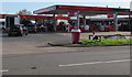
Texaco filling station, Avondale Road, Cwmbran
Part of Avondale Service Station.
Image: © Jaggery
Taken: 30 Oct 2017
0.01 miles
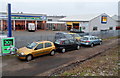
2
Nisa Local, Avondale Road, Cwmbran
Part of Avondale Service Centre. A Texaco filling station https://www.geograph.org.uk/photo/5626794 is on the left.
Image: © Jaggery
Taken: 30 Oct 2017
0.01 miles
3
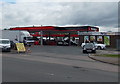
Avondale Service Station, Cwmbran
The service station is a Texaco filling station and Nisa Local shop (formerly a Mace shop).
Image: © Jaggery
Taken: 24 May 2013
0.01 miles
4
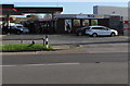
ATS Euromaster Centre, Cwmbran
Located on the north side of Station Road in the Pontnewydd area of Cwmbran, this is one of more than 450 ATS Euromaster Centres in the UK. The business supplies vehicle-related products and services such as tyres, wheel alignment, MoT testing, batteries, brakes, shocks, exhausts and oil change.
Image: © Jaggery
Taken: 12 Dec 2012
0.03 miles
5
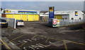
ATS Euromaster, Cwmbran
Located on the north side of Station Road, this is one of several hundred ATS Euromaster centres in the UK.
The business supplies vehicle-related products and services such as tyres, wheel alignment, MoT testing, batteries, brakes, shocks, exhausts and oil change.
Image: © Jaggery
Taken: 15 Feb 2015
0.03 miles
6
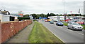
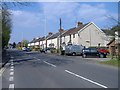
Avondale Road,Pontnewydd, Cwmbran
Looking northeastwards along Avondale Road, from the Station Road junction. On the left is the perimeter wall of St David's Catholic Church. http://www.geograph.org.uk/photo/1611683 On the right are the Newtown Motors premises.
Image: © Jaggery
Taken: 17 Sep 2009
0.04 miles
7
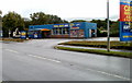
Cwmbran Valeting Centre
Car wash and valeting premises, located on Avondale Road, opposite the turning for Blaen Bran Close.http://www.geograph.org.uk/photo/2079362
Image: © Jaggery
Taken: 23 Sep 2010
0.04 miles
8
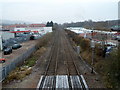
Site of former Lower Pontnewydd railway station, Cwmbran
Viewed from Station Road bridge looking north. A 1940s map shows that Lower Pontnewydd railway station was located here, immediately north of the bridge. Passenger services at Lower Pontnewydd railway station ceased in 1958.
Image: © Jaggery
Taken: 12 Dec 2012
0.04 miles
9
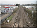
Lower Pontnewydd railway station (site), Gwent
Opened in 1858 by the Pontypool Caerleon & Newport Railway, soon to become part of the Great Western Railway, this station closed to passengers in 1958 and completely in 1965.
View north towards Panteg and Pontypool. No trace appears to remain.
Image: © Nigel Thompson
Taken: 14 Mar 2015
0.05 miles