IMAGES TAKEN NEAR TO
St. Andrews Close, CWMBRAN, NP44 1TA
Introduction
This page details the photographs taken nearby to St. Andrews Close, NP44 1TA by members of the Geograph project.
The Geograph project started in 2005 with the aim of publishing, organising and preserving representative images for every square kilometre of Great Britain, Ireland and the Isle of Man.

There are currently over 7.5m images from over14,400 individuals and you can help contribute to the project by visiting https://www.geograph.org.uk
Image Map
Images are licensed for reuse under creativecommons.org/licenses/by-sa/2.0
Notes
- Clicking on the map will re-center to the selected point.
- The higher the marker number, the further away the image location is from the centre of the postcode.
Image Listing (105 Images Found)
Images are licensed for reuse under creativecommons.org/licenses/by-sa/2.0
Image
Details
Distance
1
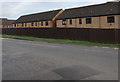
St Andrews Close houses behind a fence, Pontrhydyrun, Cwmbran
Viewed across Pontrhydyrun Road.
Image: © Jaggery
Taken: 6 Mar 2019
0.02 miles
2
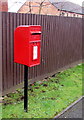
Queen Elizabeth II postbox alongside a fence, Pontrhydyrun Road, Cwmbran
Located here. https://www.geograph.org.uk/photo/6083466
Image: © Jaggery
Taken: 6 Mar 2019
0.02 miles
3
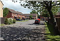
St Andrews Close, Cwmbran
Located in the Pontrhydyrun district at the northern edge of Cwmbran.
Image: © Jaggery
Taken: 24 May 2013
0.02 miles
4
National Cycle Route 423 direction sign, Pontrhydyrun Road, Cwmbran
The sign points towards National Cycle Network Route 423 which follows the former Regional Route 30 and the Peregrine Path from Cwmbran to Ross-on-Wye via Monmouth.
Image: © Jaggery
Taken: 6 Mar 2019
0.03 miles
5
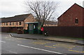
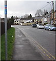
Pontrhydyrun Road bus stop and shelter, Cwmbran
In March 2019 this is a stop on Stagecoach bus route 15 to Newport via Cwmbran bus station.
Image: © Jaggery
Taken: 6 Mar 2019
0.03 miles
6
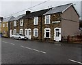
Row of stone houses, Pontrhydyrun Road, Cwmbran
The leftmost house used to be Pontrhydyrun Post Office.
Image: © Jaggery
Taken: 6 Mar 2019
0.04 miles
7
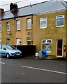
Former Pontrhydyrun Post Office, Cwmbran
In March 2019 the long derelict former post office on the right,
seen here https://www.geograph.org.uk/photo/1576985 in October 2009, is being converted to residential use.
Image: © Jaggery
Taken: 6 Mar 2019
0.04 miles
8
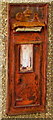
Disused King George V postbox in Cwmbran
The sealed former postbox is located here https://www.geograph.org.uk/photo/6083498
in the wall of the former Pontrhydyrun Post Office.
It has been replaced by this postbox https://www.geograph.org.uk/photo/6083472
on the opposite side of the road.
Image: © Jaggery
Taken: 6 Mar 2019
0.04 miles
9
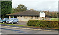
Pontrhydyrun Community Hall, Cwmbran
Located on Pontrhydyrun Road, close to the junction with Avondale Road.
Image: © Jaggery
Taken: 21 Oct 2009
0.04 miles
10
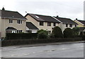
Houses on the south side of Pontrhydyrun Road, Cwmbran
Pontrhydyrun Road extends for 400 metres from Avondale Road (behind the camera) to the A4051 Cwmbran Drive.
Image: © Jaggery
Taken: 6 Mar 2019
0.04 miles