IMAGES TAKEN NEAR TO
Penyparc, CWMBRAN, NP44 1SF
Introduction
This page details the photographs taken nearby to Penyparc, NP44 1SF by members of the Geograph project.
The Geograph project started in 2005 with the aim of publishing, organising and preserving representative images for every square kilometre of Great Britain, Ireland and the Isle of Man.

There are currently over 7.5m images from over14,400 individuals and you can help contribute to the project by visiting https://www.geograph.org.uk
Image Map
Images are licensed for reuse under creativecommons.org/licenses/by-sa/2.0
Notes
- Clicking on the map will re-center to the selected point.
- The higher the marker number, the further away the image location is from the centre of the postcode.
Image Listing (223 Images Found)
Images are licensed for reuse under creativecommons.org/licenses/by-sa/2.0
Image
Details
Distance
1
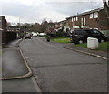
Penyparc, Cwmbran
Penyparc (Pen-y-parc in Welsh) is a cul-de-sac on the south side of Five Locks Road.
Image: © Jaggery
Taken: 6 Mar 2019
0.04 miles
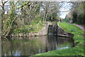
2
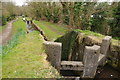
Disused locks, Cwmbran
Disused locks on the Monmouthshire and Brecon Canal at West Pontnewydd near Cwmbran.
Image: © Philip Halling
Taken: 12 Apr 2013
0.05 miles
3
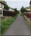
Path towards Parc Avenue, Cwmbran
Ascending from Fields Avenue.
Image: © Jaggery
Taken: 20 Sep 2016
0.06 miles
4
Western end of Parc Avenue, Cwmbran
West of Clark Avenue.
Image: © Jaggery
Taken: 20 Sep 2016
0.06 miles
5
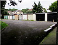
Row of lockup garages, Fields Avenue, Pontnewydd, Cwmbran
The garages are on the north bank of a brook, Blaen Bran, at the western end of Fields Avenue.
Image: © Jaggery
Taken: 20 Sep 2016
0.06 miles
7
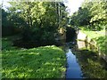
The foot of Five Locks, Monmouthshire and Brecon Canal
Image: © David Smith
Taken: 29 Sep 2021
0.07 miles
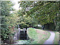
8
Disused lock gates, Five Locks, Pontnewydd
Partly restored lock on a disused section of the Mon & Brec Canal. The tow path is part of NCR 49.
Image: © M J Roscoe
Taken: 12 Apr 2019
0.07 miles
9
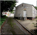
Scout Hall, Fields Avenue, Cwmbran
The 1st Pontnewydd Scout Group hall is at the western end of Fields Avenue.
The centenary plaque above the door shows 1910-2010.
Image: © Jaggery
Taken: 20 Sep 2016
0.07 miles
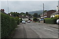
10
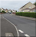
Up Clark Avenue, Cwmbran
From the corner of Parc Avenue, Clark Avenue ascends towards Lowlands Crescent.
Image: © Jaggery
Taken: 20 Sep 2016
0.07 miles