IMAGES TAKEN NEAR TO
Moseley Terrace, CWMBRAN, NP44 1SA
Introduction
This page details the photographs taken nearby to Moseley Terrace, NP44 1SA by members of the Geograph project.
The Geograph project started in 2005 with the aim of publishing, organising and preserving representative images for every square kilometre of Great Britain, Ireland and the Isle of Man.

There are currently over 7.5m images from over14,400 individuals and you can help contribute to the project by visiting https://www.geograph.org.uk
Image Map
Images are licensed for reuse under creativecommons.org/licenses/by-sa/2.0
Notes
- Clicking on the map will re-center to the selected point.
- The higher the marker number, the further away the image location is from the centre of the postcode.
Image Listing (99 Images Found)
Images are licensed for reuse under creativecommons.org/licenses/by-sa/2.0
Image
Details
Distance
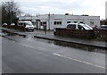
1
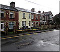
Houses at the southwest end of Pontrhydyrun Road, Cwmbran
On the approach to the A4051 Cwmbran Drive.
Image: © Jaggery
Taken: 6 Mar 2019
0.03 miles
2
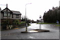
Pedestrian refuge at the southwest end of Pontrhydyrun Road, Cwmbran
On the approach to the A4051 Cwmbran Drive.
Image: © Jaggery
Taken: 6 Mar 2019
0.03 miles
3
BT phonebox, Pontrhydyrun Road, Cwmbran
The phonebox appears to be doorless by design rather than because of vandalism.
Image: © Jaggery
Taken: 6 Mar 2019
0.03 miles
4
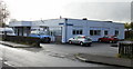
Scope Cwmbran Skills Development Centre, Pontrhydyrun
Located on Avondale Way, Pontrhydyrun, Cwmbran. Scope is a charity focusing on people with cerebral palsy particularly, and disabled people in general. Its aim is that disabled people achieve equality.
Image: © Jaggery
Taken: 21 Oct 2009
0.03 miles
5
Cwmbran Day Opportunities centre, Avondale Drive, Cwmbran
Cwmbran Day Opportunities (Ambito Cwmbran) provides a day service for disabled adults living in Cwmbran and surrounding areas.
Image: © Jaggery
Taken: 6 Mar 2019
0.04 miles
6
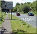
Cwmbran Drive heads south towards Pontrhydyrun
Much of the A4051 Cwmbran Drive follows the route of dismantled railways, as here,
between Sebastopol, Pontypool behind the camera and Pontrhydyrun, Cwmbran ahead.
Image: © Jaggery
Taken: 24 May 2013
0.04 miles
7
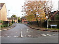
St Andrews Close, Pontrhydyrun, Cwmbran
Viewed from Avondale Drive.
Image: © Jaggery
Taken: 21 Oct 2009
0.04 miles
8
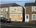
Former Post Office, Pontrhydyrun, Cwmbran
This boarded-up and derelict property was formerly Pontrhydyrun post office. http://www.geograph.org.uk/photo/1576991 for a closeup of the George V postbox.
Image: © Jaggery
Taken: 21 Oct 2009
0.04 miles
9
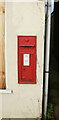
Postbox, Pontrhydyrun
The George V postbox is set into the wall of the now derelict building formerly Pontrhydyrun Post Office. http://www.geograph.org.uk/photo/1576985
Image: © Jaggery
Taken: 21 Oct 2009
0.04 miles
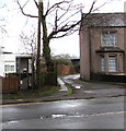
10
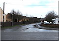
Junction of Avondale Drive and Pontrhydyrun Road, Cwmbran
From Brook Street across Pontrhydyrun Road to Avondale Drive.
Cwmbran Day Opportunities centre https://www.geograph.org.uk/photo/6087161 is on the right.
Image: © Jaggery
Taken: 6 Mar 2019
0.04 miles