IMAGES TAKEN NEAR TO
Lowlands Road, CWMBRAN, NP44 1RA
Introduction
This page details the photographs taken nearby to Lowlands Road, NP44 1RA by members of the Geograph project.
The Geograph project started in 2005 with the aim of publishing, organising and preserving representative images for every square kilometre of Great Britain, Ireland and the Isle of Man.

There are currently over 7.5m images from over14,400 individuals and you can help contribute to the project by visiting https://www.geograph.org.uk
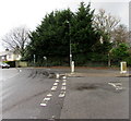
Image Map
Images are licensed for reuse under creativecommons.org/licenses/by-sa/2.0
Notes
- Clicking on the map will re-center to the selected point.
- The higher the marker number, the further away the image location is from the centre of the postcode.
Image Listing (155 Images Found)
Images are licensed for reuse under creativecommons.org/licenses/by-sa/2.0
Image
Details
Distance
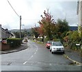
1
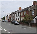
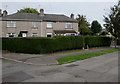
Lowlands Road houses, Cwmbran
Houses on the east side of the road north of the Parc Avenue junction.
Image: © Jaggery
Taken: 20 Sep 2016
0.01 miles
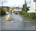
2
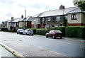
Lowlands Road, Cwmbran
Houses on the north side of the road. The view is looking in the direction of central Pontnewydd.
Image: © Jaggery
Taken: 23 Sep 2010
0.02 miles
3
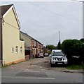
Charles Street, Pontnewydd, Cwmbran
Cul-de-sac extending for 65 metres from the east side of Lowlands Road.
Image: © Jaggery
Taken: 20 Sep 2016
0.04 miles
4
Junction of three roads in the Lowlands area of Cwmbran
Viewed from Grove Park looking towards Lowlands Road past the Lowlands Crescent junction on the right.
Image: © Jaggery
Taken: 6 Mar 2019
0.05 miles
5
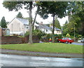
Extensive hedge, Parc Avenue, Cwmbran
The hedge extends out of shot on the left.
Image: © Jaggery
Taken: 20 Sep 2016
0.05 miles
6
Northern arm of Parc Avenue, Cwmbran
Extending for 45 metres north from the main east-west course of Parc Avenue.
Image: © Jaggery
Taken: 20 Sep 2016
0.06 miles
7
Houses in the northern section of Grove Park, Cwmbran
Both the main road and the side road to the north are named Grove Park.
Image: © Jaggery
Taken: 23 Sep 2010
0.06 miles
8
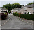
Houses at the western end of Grove Park, Cwmbran
Houses on the north side of a road (confusingly) named Grove Park, viewed from the junction with Lowlands Crescent and Lowlands Road.
Image: © Jaggery
Taken: 23 Sep 2010
0.06 miles
9
Lowlands Crescent, Cwmbran
Lowlands Crescent heads away NW from the corner of Grove Park and Lowlands Road, towards Five Locks Road.
Image: © Jaggery
Taken: 23 Sep 2010
0.06 miles
10
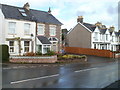
Parc Avenue, Cwmbran
Looking along Parc Avenue across Lowlands Road from the corner of Charles Street. http://www.geograph.org.uk/photo/2080091
Image: © Jaggery
Taken: 23 Sep 2010
0.07 miles