IMAGES TAKEN NEAR TO
Plas Craig, CWMBRAN, NP44 1QP
Introduction
This page details the photographs taken nearby to Plas Craig, NP44 1QP by members of the Geograph project.
The Geograph project started in 2005 with the aim of publishing, organising and preserving representative images for every square kilometre of Great Britain, Ireland and the Isle of Man.

There are currently over 7.5m images from over14,400 individuals and you can help contribute to the project by visiting https://www.geograph.org.uk
Image Map
Images are licensed for reuse under creativecommons.org/licenses/by-sa/2.0
Notes
- Clicking on the map will re-center to the selected point.
- The higher the marker number, the further away the image location is from the centre of the postcode.
Image Listing (756 Images Found)
Images are licensed for reuse under creativecommons.org/licenses/by-sa/2.0
Image
Details
Distance
1
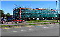
Caradoc Road flats under wraps, Cwmbran
Flats are being renovated by Westdale Services Limited in May 2018.
Image: © Jaggery
Taken: 15 May 2018
0.02 miles
2
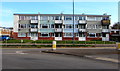
Three storey block of flats at the edge of Cwmbran town centre
Viewed across Caradoc Road.
Image: © Jaggery
Taken: 16 Apr 2020
0.02 miles
3
West along Plas Craig, Northville, Cwmbran
Towards Turberville Road.
Image: © Jaggery
Taken: 30 Oct 2017
0.03 miles
4
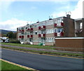
Dark red balconies, Caradoc Road, Cwmbran
Eight dark red balconies drew the eye towards an otherwise unremarkable block of flats on the north side of Caradoc Road, opposite Glyndwr Road.
Image: © Jaggery
Taken: 23 Sep 2010
0.03 miles
5
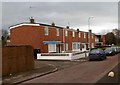
Houses on the north side of Plas Craig, Cwmbran
Viewed from the Turberville Road end. The houses face flats on the south side of Plas Craig. http://www.geograph.org.uk/photo/2760399
Image: © Jaggery
Taken: 11 Jan 2012
0.03 miles
6
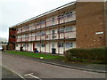
Flats on the south side of Plas Craig, Cwmbran
Viewed from the Turberville Road end. The flats face houses on the north side of Plas Craig. http://www.geograph.org.uk/photo/2760398
Image: © Jaggery
Taken: 11 Jan 2012
0.03 miles
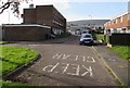
7
This way to the town centre, Cwmbran
The black arrow on the sign showing Town centre and the Welsh Canol y dref points left (westwards) along Caradoc Road. Another sign shows a 30(mph) speed limit.
Image: © Jaggery
Taken: 5 Oct 2016
0.03 miles
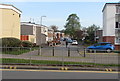
8

North along Turberville Road, Northville, Cwmbran
Viewed across Caradoc Road from the edge of Cwmbran Shopping Centre.
Image: © Jaggery
Taken: 14 Apr 2017
0.03 miles
9
North along Turberville Road, Northville, Cwmbran
Viewed across Caradoc Road.
Image: © Jaggery
Taken: 16 Apr 2020
0.03 miles
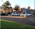
10
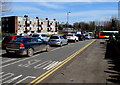
Queueing traffic on Caradoc Road, Cwmbran
Part of the one-way system in the town centre. On its way to Cwmbran
bus station, the Stagecoach bus is turning right into Glyndwr Road.
Image: © Jaggery
Taken: 25 Mar 2017
0.04 miles