IMAGES TAKEN NEAR TO
Station Road, CWMBRAN, NP44 1NY
Introduction
This page details the photographs taken nearby to Station Road, NP44 1NY by members of the Geograph project.
The Geograph project started in 2005 with the aim of publishing, organising and preserving representative images for every square kilometre of Great Britain, Ireland and the Isle of Man.

There are currently over 7.5m images from over14,400 individuals and you can help contribute to the project by visiting https://www.geograph.org.uk
Image Map
Images are licensed for reuse under creativecommons.org/licenses/by-sa/2.0
Notes
- Clicking on the map will re-center to the selected point.
- The higher the marker number, the further away the image location is from the centre of the postcode.
Image Listing (223 Images Found)
Images are licensed for reuse under creativecommons.org/licenses/by-sa/2.0
Image
Details
Distance
1
St David's Catholic Church, Cwmbran
Located on the corner of Station Road and Avondale Road.
Image: © Jaggery
Taken: 17 Sep 2009
0.00 miles
2
Row of three stone houses, Station Road, Cwmbran
On the approach to the St David's Road/Avondale Road crossroads.
Image: © Jaggery
Taken: 15 Oct 2019
0.01 miles
3
South side of St David's Catholic Church, Cwmbran
This church on the corner of Station Road and Avondale Road
is part of the Roman Catholic Archdiocese of Cardiff.
Image: © Jaggery
Taken: 30 Oct 2017
0.02 miles
4
Station Road semis, Cwmbran
Semi-detached houses near the corner of St Davids Road viewed from the corner of Avondale Road.
Image: © Jaggery
Taken: 30 Oct 2017
0.02 miles
5
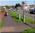
Avondale Road speed camera sign, Cwmbran
Facing northbound traffic in a 40mph maximum speed zone.
Image: © Jaggery
Taken: 30 Oct 2017
0.03 miles
6
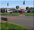
Avondale Road pelican crossing near the Station Road junction, Cwmbran
Chambers Dictionary states that pelican in this context is adapted from "pedestrian light controlled crossing".
The bilingual sign on the right shows that Avondale Road is Heol y Glyn in Welsh.
Image: © Jaggery
Taken: 30 Oct 2017
0.03 miles
7
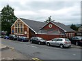
Ebenezer Congregational Hall
The date sign on the wall is a little confusing - is it 1889 or 1898?
Image: © Graham Hogg
Taken: 20 May 2013
0.04 miles
8
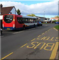
X3 bus, St David's Road, Cwmbran
Heading north, Stagecoach bus 28730 is on route X3 to Pontypool.
Image: © Jaggery
Taken: 16 Oct 2019
0.05 miles
9

Information board outside Ebenezer Evangelical Church (Congregational), Cwmbran
On display in early September 2019 on the Station Road side of this church. https://www.geograph.org.uk/photo/6259045
Sunday Services begin at 10:30am & 6pm. Tuesday Prayer Meeting from 7pm.
Image: © Jaggery
Taken: 7 Sep 2019
0.05 miles
10

Esporta Health Club, Cwmbran
Located on the west side of Avondale Road.
UPDATE 2013 Now a Virgin Active Health Club. http://www.geograph.org.uk/photo/3473882
Image: © Jaggery
Taken: 23 Sep 2010
0.06 miles