IMAGES TAKEN NEAR TO
Plas Islwyn, CWMBRAN, NP44 1NN
Introduction
This page details the photographs taken nearby to Plas Islwyn, NP44 1NN by members of the Geograph project.
The Geograph project started in 2005 with the aim of publishing, organising and preserving representative images for every square kilometre of Great Britain, Ireland and the Isle of Man.

There are currently over 7.5m images from over14,400 individuals and you can help contribute to the project by visiting https://www.geograph.org.uk
Image Map
Images are licensed for reuse under creativecommons.org/licenses/by-sa/2.0
Notes
- Clicking on the map will re-center to the selected point.
- The higher the marker number, the further away the image location is from the centre of the postcode.
Image Listing (553 Images Found)
Images are licensed for reuse under creativecommons.org/licenses/by-sa/2.0
Image
Details
Distance
1
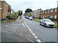
Central section of Porth Mawr Road, Cwmbran
Looking north from the corner of Plas Islwyn.
Image: © Jaggery
Taken: 20 Jul 2011
0.02 miles
2
Northern section of Porth Mawr Road, Cwmbran
The view NNE from the corner of Mead Lane. http://www.geograph.org.uk/photo/2514277
Image: © Jaggery
Taken: 20 Jul 2011
0.02 miles
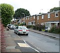
3
Southern end of Porth Mawr Road, Cwmbran
The view north from near the corner of Conway Close.
Image: © Jaggery
Taken: 20 Jul 2011
0.04 miles
4
Long Hollow, Cwmbran
Long Hollow is a short, residential cul-de-sac on the east side of Porth Mawr Road.
Image: © Jaggery
Taken: 20 Jul 2011
0.04 miles
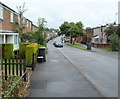
5
Mead Lane, Cwmbran
Viewed from Porth Mawr Road, looking towards Maendy Primary School.
Image: © Jaggery
Taken: 20 Jul 2011
0.05 miles
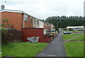
6
Maendy Primary School, Cwmbran
Viewed from Wayfield Crescent. This is one of two buildings on the school site, which formerly contained Maendy Junior School and Maendy Infants School. The schools are now combined as Maendy Primary School.
Image: © Jaggery
Taken: 20 Jul 2011
0.05 miles
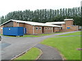
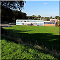
7
Southern side of Maendy Primary School, Cwmbran
Viewed from Maendy Way. This is one of two buildings on the school site, which formerly contained Maendy Junior School and Maendy Infants School. The schools are now combined as Maendy Primary School.
Image: © Jaggery
Taken: 13 Oct 2011
0.05 miles
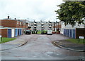
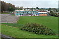
8
Maendy Primary School, Cwmbran
Viewed from Maendy Way. The school is accessed from Wayfield Crescent.
Image: © Jaggery
Taken: 5 Oct 2016
0.06 miles
9
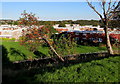
Nearly horizontal tree below Maendy Way, Cwmbran
Whatever caused the tree to be aligned this way (perhaps a vehicle collision, or subsidence or vandalism)
doesn't appear to have seriously damaged the tree which has many red berries on October 5th 2016.
Image: © Jaggery
Taken: 5 Oct 2016
0.06 miles
10
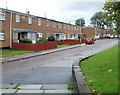
Trussel Road, Cwmbran
Houses on the south side of Trussel Road, viewed from the St David's Road end.
Image: © Jaggery
Taken: 23 Sep 2010
0.07 miles