IMAGES TAKEN NEAR TO
Conway Close, CWMBRAN, NP44 1NE
Introduction
This page details the photographs taken nearby to Conway Close, NP44 1NE by members of the Geograph project.
The Geograph project started in 2005 with the aim of publishing, organising and preserving representative images for every square kilometre of Great Britain, Ireland and the Isle of Man.

There are currently over 7.5m images from over14,400 individuals and you can help contribute to the project by visiting https://www.geograph.org.uk
Image Map
Images are licensed for reuse under creativecommons.org/licenses/by-sa/2.0
Notes
- Clicking on the map will re-center to the selected point.
- The higher the marker number, the further away the image location is from the centre of the postcode.
Image Listing (795 Images Found)
Images are licensed for reuse under creativecommons.org/licenses/by-sa/2.0
Image
Details
Distance
1

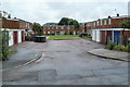
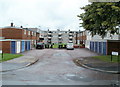
Conway Close houses, Cwmbran
Set back from the north side of Caradoc Road.
Image: © Jaggery
Taken: 5 Oct 2016
0.02 miles
2
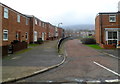
Grange Lane, Cwmbran
Grange Lane is a short, residential cul-de-sac on the east side of Porth Mawr Road.
Image: © Jaggery
Taken: 20 Jul 2011
0.03 miles
3
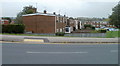
Conway Close, Cwmbran
Viewed across Maendy Way. Conway Close houses are aligned parallel with Caradoc Road, about 50 metres to the south (out of shot on the right). The distant houses aligned at right angles to Conway Close are part of Porth Mawr Road.
Image: © Jaggery
Taken: 13 Oct 2011
0.03 miles
4
Llandaff Green, Cwmbran
Viewed from the corner of Turberville Road. In the distance are houses on Porthmawr Road.
Image: © Jaggery
Taken: 11 Jan 2012
0.03 miles
5
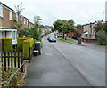
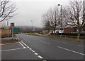
Southern end of Porth Mawr Road, Cwmbran
The view north from near the corner of Conway Close.
Image: © Jaggery
Taken: 20 Jul 2011
0.04 miles
6
Long Hollow, Cwmbran
Long Hollow is a short, residential cul-de-sac on the east side of Porth Mawr Road.
Image: © Jaggery
Taken: 20 Jul 2011
0.04 miles
7
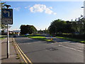
One-way traffic on Caradoc Road, Cwmbran
The No Entry sign is on the corner of an exit road from an Asda superstore car park.
All traffic leaving the car park must turn right here.
Image: © Jaggery
Taken: 26 Feb 2013
0.04 miles
8
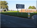
Directions signs facing Maendy Way, Cwmbran
Left for Newport, Pontypool and the Springvale, Pontnewydd, Greenmeadow and Upper Cwmbran areas of Cwmbran. Right for Cwmbran town centre, railway station and free car parks.
Image: © Jaggery
Taken: 5 Oct 2016
0.05 miles
9

Caradoc Road houses, Northville, Cwmbran
On the north side of Caradoc Road at the edge of the town centre.
Image: © Jaggery
Taken: 7 Sep 2017
0.05 miles
10
One way, two languages, three words, Maendy Way, Cwmbran
The English/Welsh One way/Unffordd sign is near the point where Maendy Way splits into two one-way carriageways.
Image: © Jaggery
Taken: 5 Oct 2016
0.05 miles