IMAGES TAKEN NEAR TO
Plas Trosnant, CWMBRAN, NP44 1ND
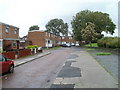
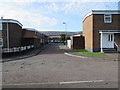
Introduction
This page details the photographs taken nearby to Plas Trosnant, NP44 1ND by members of the Geograph project.
The Geograph project started in 2005 with the aim of publishing, organising and preserving representative images for every square kilometre of Great Britain, Ireland and the Isle of Man.

There are currently over 7.5m images from over14,400 individuals and you can help contribute to the project by visiting https://www.geograph.org.uk
Image Map
Images are licensed for reuse under creativecommons.org/licenses/by-sa/2.0
Notes
- Clicking on the map will re-center to the selected point.
- The higher the marker number, the further away the image location is from the centre of the postcode.
Image Listing (341 Images Found)
Images are licensed for reuse under creativecommons.org/licenses/by-sa/2.0
Image
Details
Distance
1
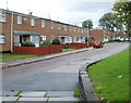
Western end of Ty Mynydd, Northville, Cwmbran
Houses on the north side of Ty Mynydd, viewed from the corner of Porth Mawr Road.
Image: © Jaggery
Taken: 20 Jul 2011
0.02 miles
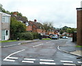
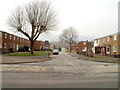
2
Northville, Cwmbran
From Maendy Way. The Northville area of Cwmbran is between the town centre and the Pontnewydd area.
Image: © Jaggery
Taken: 5 Oct 2016
0.03 miles
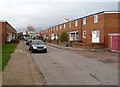
3
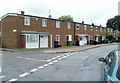
96-86 Porth Mawr Road, Cwmbran
Viewed from opposite the Ty Mynydd http://www.geograph.org.uk/photo/2514297 junction. The row contains six houses, 96 to 86 Porth Mawr Road (even numbers only).
Image: © Jaggery
Taken: 20 Jul 2011
0.05 miles
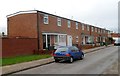
4
Ty Mynydd, Cwmbran
Viewed from the Station Road end. Ahead, the course of Ty Mynydd splits into two arms. The left arm is a cul-de-sac; the right arm connects with Porth Mawr Road.
Image: © Jaggery
Taken: 23 Sep 2010
0.05 miles
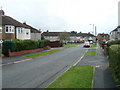
5
Trussel Road, Cwmbran
Houses on the south side of Trussel Road, viewed from the St David's Road end.
Image: © Jaggery
Taken: 23 Sep 2010
0.08 miles
6
Trussel Road, Cwmbran
The view west along Trussel Road from the corner of St David's Road.
Image: © Jaggery
Taken: 28 Mar 2011
0.08 miles
7
Cwmbran : Turberville Road north of Isca Close
Looking north towards Trussel Road.
Image: © Jaggery
Taken: 11 Jan 2012
0.08 miles
8
Turberville Road houses north of St Woolos Green, Cwmbran
Houses on the west side of Turberville Road, viewed looking towards Trussel Road.
Image: © Jaggery
Taken: 11 Jan 2012
0.08 miles
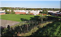
9
Northern side of Plas Twyn, Cwmbran
Plas Twyn runs alongside St David's Road, and is separated from it by the bank and hedge on the right. There is a small playground at the end of Plas Twyn, just out of shot on the left.
Image: © Jaggery
Taken: 23 Sep 2010
0.08 miles
10
Plas Twyn, Northville, Cwmbran
Houses on the west side of St David's Road.
Image: © Jaggery
Taken: 30 Oct 2017
0.08 miles