IMAGES TAKEN NEAR TO
Porthmawr Road, CWMBRAN, NP44 1NB
Introduction
This page details the photographs taken nearby to Porthmawr Road, NP44 1NB by members of the Geograph project.
The Geograph project started in 2005 with the aim of publishing, organising and preserving representative images for every square kilometre of Great Britain, Ireland and the Isle of Man.

There are currently over 7.5m images from over14,400 individuals and you can help contribute to the project by visiting https://www.geograph.org.uk
Image Map
Images are licensed for reuse under creativecommons.org/licenses/by-sa/2.0
Notes
- Clicking on the map will re-center to the selected point.
- The higher the marker number, the further away the image location is from the centre of the postcode.
Image Listing (310 Images Found)
Images are licensed for reuse under creativecommons.org/licenses/by-sa/2.0
Image
Details
Distance
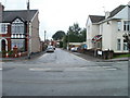
1
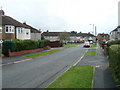
Ty Mynydd, Cwmbran
Viewed from the Station Road end. Ahead, the course of Ty Mynydd splits into two arms. The left arm is a cul-de-sac; the right arm connects with Porth Mawr Road.
Image: © Jaggery
Taken: 23 Sep 2010
0.05 miles
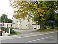
2
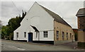
The Well Centre, Pontnewydd
Located on Station Road. Formerly Trinity Presbyterian Church, built in 1903 and rebuilt in 1934. The building is now The Well Centre, the administrative headquarters of The Order of Jacob's Well. Founded by a group of lay and ordained Christians involved in the Christian healing ministry in South Wales, the Order of Jacob's Well now has ministries in England, Scotland and Wales, and is expanding worldwide.
Image: © Jaggery
Taken: 17 Sep 2009
0.05 miles
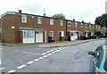
3
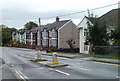
Station Road houses, Cwmbran
Houses on the south side of Station Road. The turning on the right is in to William Street, leading to Porth Mawr Road.
Image: © Jaggery
Taken: 23 Sep 2010
0.05 miles
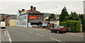
4
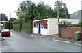
Everything & Anything, Porth Mawr Road, Cwmbran
Located in Urella Stores. Notices on the single-storey premises state
"Scrap gold wanted bought and sold" and
"Selection of new furniture, and household items, always available."
Image: © Jaggery
Taken: 23 Sep 2010
0.05 miles
5
William Street, Cwmbran
Viewed across Station Road. A few metres ahead, William Street leads to Porth Mawr Road.
Image: © Jaggery
Taken: 23 Sep 2010
0.05 miles
6
Oriental Garden II, Pontnewydd, Cwmbran
Chinese Restaurant at 53 Station Road. The sign next to the car states "Buffet Restaurant - Eat as much as you like!"
Formerly the Kings Head pub.
Image: © Jaggery
Taken: 17 Sep 2009
0.07 miles
7
Royal British Legion, Pontnewydd
Royal British Legion's Pontnewydd Club and Branch, on the south side of Station Road.
Image: © Jaggery
Taken: 17 Sep 2009
0.07 miles
8
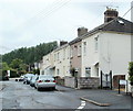
96-86 Porth Mawr Road, Cwmbran
Viewed from opposite the Ty Mynydd http://www.geograph.org.uk/photo/2514297 junction. The row contains six houses, 96 to 86 Porth Mawr Road (even numbers only).
Image: © Jaggery
Taken: 20 Jul 2011
0.08 miles
9
Cromwell Place, Cwmbran
Looking along the SW end of Cromwell Place, towards Wayfield Crescent.
Image: © Jaggery
Taken: 20 Jul 2011
0.08 miles
10
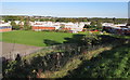
Northville, Cwmbran
From Maendy Way. The Northville area of Cwmbran is between the town centre and the Pontnewydd area.
Image: © Jaggery
Taken: 5 Oct 2016
0.08 miles