1
Ty Box Road, Cwmbran
Houses on the north side of Maendy Way.
Image: © Jaggery
Taken: 9 Apr 2014
0.08 miles
2
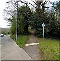
Footpath from Maendy Way to Church Wood Road, Cwmbran
The path heads towards the SE corner of Church Wood Road, about 100 metres ahead.
Image: © Jaggery
Taken: 9 Apr 2014
0.08 miles
3
Southern end of Trinity Road, Cwmbran
Viewed across Maendy Way.
Image: © Jaggery
Taken: 9 Apr 2014
0.08 miles
4
Ty Box Road, Cwmbran
Image: © David Smith
Taken: 29 Sep 2021
0.10 miles
5
Bus stop in woodland, Cwmbran
This part of Maendy Way is through Church Wood. The bus stop is opposite Trinity Road. http://www.geograph.org.uk/photo/3926438
Image: © Jaggery
Taken: 9 Apr 2014
0.10 miles
6
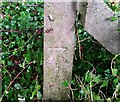
Ordnance Survey Cut Mark
This OS cut mark can be found on a concrete post south side of Maendy Way. It marks a point 95.570m above mean sea level.
Image: © Adrian Dust
Taken: 17 Aug 2020
0.10 miles
7
Ordnance Survey Rivet
This OS rivet can be found on the base of the now removed lamp standard in the centre of the roundabout. It marks a point 86.620m above mean sea level.
Image: © Adrian Dust
Taken: 17 Aug 2020
0.10 miles
8
Holy Trinity Church, Pontnewydd, Cwmbran
Located in the SW corner of a large churchyard, The Church in Wales church is set back about 150 metres from Mount Pleasant Road. Built in 1860, the church was Grade II listed in 2000.
http://www.geograph.org.uk/photo/3730130 to a back view.
Image: © Jaggery
Taken: 4 Nov 2013
0.11 miles
9
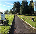
Path to Holy Trinity Church, Pontnewydd, Cwmbran
The path leads from Mount Pleasant Road to the Grade II listed church http://www.geograph.org.uk/photo/3730127 about 150 metres ahead.
Image: © Jaggery
Taken: 4 Nov 2013
0.11 miles
10
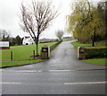
Entrance drive to Peterson Funeral Home, Woodside House, Cwmbran
Viewed from Maendy Way. http://www.geograph.org.uk/photo/1784041 to Woodside House.
Image: © Jaggery
Taken: 3 Apr 2010
0.12 miles


