IMAGES TAKEN NEAR TO
Trinity Road, CWMBRAN, NP44 1LG
Introduction
This page details the photographs taken nearby to Trinity Road, NP44 1LG by members of the Geograph project.
The Geograph project started in 2005 with the aim of publishing, organising and preserving representative images for every square kilometre of Great Britain, Ireland and the Isle of Man.

There are currently over 7.5m images from over14,400 individuals and you can help contribute to the project by visiting https://www.geograph.org.uk
Image Map
Images are licensed for reuse under creativecommons.org/licenses/by-sa/2.0
Notes
- Clicking on the map will re-center to the selected point.
- The higher the marker number, the further away the image location is from the centre of the postcode.
Image Listing (161 Images Found)
Images are licensed for reuse under creativecommons.org/licenses/by-sa/2.0
Image
Details
Distance
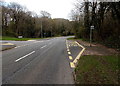
1
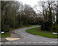
Southern end of Trinity Road, Cwmbran
Viewed across Maendy Way.
Image: © Jaggery
Taken: 9 Apr 2014
0.06 miles
2
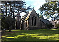
Holy Trinity Church, Pontnewydd, Cwmbran
Located in the SW corner of a large churchyard, The Church in Wales church is set back about 150 metres from Mount Pleasant Road. Built in 1860, the church was Grade II listed in 2000.
http://www.geograph.org.uk/photo/3730130 to a back view.
Image: © Jaggery
Taken: 4 Nov 2013
0.07 miles
3
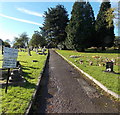
Path to Holy Trinity Church, Pontnewydd, Cwmbran
The path leads from Mount Pleasant Road to the Grade II listed church http://www.geograph.org.uk/photo/3730127 about 150 metres ahead.
Image: © Jaggery
Taken: 4 Nov 2013
0.07 miles
4
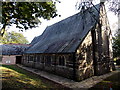
Back of Holy Trinity Church, Pontnewydd, Cwmbran
Located in the SW corner of a large churchyard, The Church in Wales church is set back about 150 metres from Mount Pleasant Road. Built in 1860, the church was Grade II listed in 2000.
http://www.geograph.org.uk/photo/3730127 to a front view.
Image: © Jaggery
Taken: 4 Nov 2013
0.08 miles
5

Northeast side of Holy Trinity Church, Pontnewydd, Cwmbran
Church in Wales church in the Diocese of Monmouth. The church was erected in 1859-1860. It was Grade II listed in 2000 as a High Victorian church of definite architectural quality designed by the leading church architects of the period in Wales.
Image: © Jaggery
Taken: 6 Mar 2019
0.09 miles
6
Bus stop in woodland, Cwmbran
This part of Maendy Way is through Church Wood. The bus stop is opposite Trinity Road. http://www.geograph.org.uk/photo/3926438
Image: © Jaggery
Taken: 9 Apr 2014
0.10 miles
7
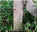
Ordnance Survey Cut Mark
This OS cut mark can be found on a concrete post south side of Maendy Way. It marks a point 95.570m above mean sea level.
Image: © Adrian Dust
Taken: 17 Aug 2020
0.10 miles
8
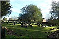
Holy Trinity churchyard, Pontnewydd,Cwmbran
View from near the SE corner of the Grade II listed church. http://www.geograph.org.uk/photo/3730127
Image: © Jaggery
Taken: 4 Nov 2013
0.10 miles
9
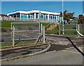
The Nursery, Pontnewydd Primary School, Cwmbran
Located on the east side of the Pontnewydd Primary School site. Viewed from Church Road.
Image: © Jaggery
Taken: 4 Nov 2013
0.10 miles
10
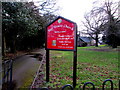
Information board on the approach to Holy Trinity Church, Pontnewydd, Cwmbran
On the approach to this church https://www.geograph.org.uk/photo/6108591 the board on display in March 2019 shows that Sunday services begin at 10am and 6pm. Friday services start at 9:30am.
Image: © Jaggery
Taken: 6 Mar 2019
0.11 miles