IMAGES TAKEN NEAR TO
Maendy Way, CWMBRAN, NP44 1LB
Introduction
This page details the photographs taken nearby to Maendy Way, NP44 1LB by members of the Geograph project.
The Geograph project started in 2005 with the aim of publishing, organising and preserving representative images for every square kilometre of Great Britain, Ireland and the Isle of Man.

There are currently over 7.5m images from over14,400 individuals and you can help contribute to the project by visiting https://www.geograph.org.uk
Image Map (Loading...)


Getting Data...Please wait
Leaflet Map data © OpenStreetMap
Images are licensed for reuse under creativecommons.org/licenses/by-sa/2.0
Notes
- Clicking on the map will re-center to the selected point.
- The higher the marker number, the further away the image location is from the centre of the postcode.
Image Listing (271 Images Found)
Images are licensed for reuse under creativecommons.org/licenses/by-sa/2.0
Image
Details
Distance
1
Traffic counting strips across Maendy Way, Cwmbran
The strips contain sensors that send traffic data (as vehicles pass over them)
to a MetroCount box padlocked to the metal post on the right.
Image: © Jaggery
Taken: 9 Apr 2014
0.02 miles
3
Monmouthshire and Brecon Canal, Forge Hammer
Image: © David Smith
Taken: 29 Sep 2021
0.04 miles
4
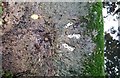
Ordnance Survey Rivet
This OS rivet can be found on the culvert north side of Maendy Way. It marks a point 77.540m above mean sea level.
Image: © Adrian Dust
Taken: 17 Aug 2020
0.04 miles
5
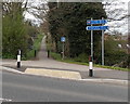
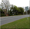
Precisely equidistant signpost alongside Maendy Way, Cwmbran
Left for Springvale Industrial Estate 660 yards. Right for Cwmbran town centre 660 yards.
Great precision is not the same thing as great accuracy, especially as in this case, both destinations are large areas. The path heading north away from Maendy Way is part of National Cycle Network route 49 alongside the disused Monmouthshire & Brecon Canal.
Image: © Jaggery
Taken: 9 Apr 2014
0.05 miles
6
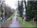
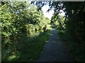
National Cycle Network Route 49, Cwmbran
Route 49 heads north from Maendy Way, Cwmbran along the towpath of the former Monmouthshire and Brecon canal. The canal is fragmented in this part of Cwmbran. For example, it does not cross Maendy Way, and there is a gap of about 200 metres a little north of here.
Image: © Jaggery
Taken: 3 Apr 2010
0.05 miles
7
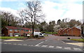
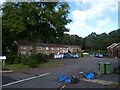
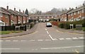
Ty Box Road, Cwmbran
Houses on the north side of Maendy Way.
Image: © Jaggery
Taken: 9 Apr 2014
0.05 miles
8
National Cycle Route 49 beside the Monmouthshire and Brecon Canal
Image: © JThomas
Taken: 18 Oct 2019
0.05 miles
9
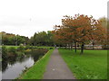
Monmouthshire & Brecon: approaching Maendy Way
Image: © Gareth James
Taken: 23 Oct 2011
0.06 miles
10
Laybourne Close, Pontnewydd, Cwmbran
Laybourne Close has the shape of the letter T. This view, along the tail of the T, is from Chapel Street.
Image: © Jaggery
Taken: 26 Mar 2011
0.06 miles