IMAGES TAKEN NEAR TO
Maendy Way, CWMBRAN, NP44 1HW
Introduction
This page details the photographs taken nearby to Maendy Way, NP44 1HW by members of the Geograph project.
The Geograph project started in 2005 with the aim of publishing, organising and preserving representative images for every square kilometre of Great Britain, Ireland and the Isle of Man.

There are currently over 7.5m images from over14,400 individuals and you can help contribute to the project by visiting https://www.geograph.org.uk
Image Map
Images are licensed for reuse under creativecommons.org/licenses/by-sa/2.0
Notes
- Clicking on the map will re-center to the selected point.
- The higher the marker number, the further away the image location is from the centre of the postcode.
Image Listing (85 Images Found)
Images are licensed for reuse under creativecommons.org/licenses/by-sa/2.0
Image
Details
Distance
1
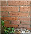
Ordnance Survey Cut Mark
This OS cut mark can be found on No61 Maendy Way. It marks a point 136.020m above mean sea level.
Image: © Adrian Dust
Taken: 17 Aug 2020
0.01 miles
2
Grassy bank strimming, Maendy Way, Cwmbran
A man on the left, and several men on the right, are strimming a grassy bank on March 29th 2017.
Image: © Jaggery
Taken: 29 Mar 2017
0.02 miles
3
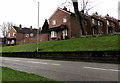
Brick houses and wall above Maendy Way, Cwmbran
Between Maendy Way and Greenwood Avenue.
Image: © Jaggery
Taken: 29 Mar 2017
0.02 miles
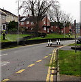
4
Priority over oncoming vehicles, Maendy Way, Cwmbran
As a traffic calming measure, the width of Maendy Way on the right is reduced
to one lane for a couple of metres. The sign's text is also in Welsh.
Image: © Jaggery
Taken: 29 Mar 2017
0.04 miles
5
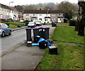
Wheelie bins and recycling boxes in West Pontnewydd, Cwmbran
In Heol y Pwca near the corner of Nant Celyn Close.
Image: © Jaggery
Taken: 29 Mar 2017
0.04 miles
6
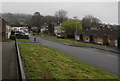
Heol y Pwca, West Pontnewydd, Cwmbran
Heol y Pwca is between Maendy Wood Rise behind the camera and Mynydd Maen Road out of shot ahead.
Image: © Jaggery
Taken: 29 Mar 2017
0.04 miles
7
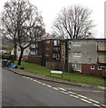
Flats near the corner of Heol y Pwca and Nant Celyn Close, West Pontnewydd, Cwmbran
Viewed across Heol y Pwca.
Image: © Jaggery
Taken: 29 Mar 2017
0.05 miles
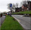
8
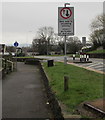
Give way to oncoming vehicles, Maendy Way, Cwmbran
As a traffic calming measure, the width of Maendy Way on the right is reduced
to one lane for a couple of metres. The sign's text is also in Welsh.
Image: © Jaggery
Taken: 29 Mar 2017
0.06 miles
9
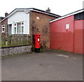
Queen Elizabeth II pillarbox, Maendy Square, West Pontnewydd, Cwmbran
On the left here. http://www.geograph.org.uk/photo/5329263
Image: © Jaggery
Taken: 29 Mar 2017
0.06 miles
10
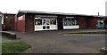
Jessica's Boutique, West Pontnewydd, Cwmbran
At the western end of Maendy Square shops.
Image: © Jaggery
Taken: 29 Mar 2017
0.06 miles