IMAGES TAKEN NEAR TO
Maendy Way, CWMBRAN, NP44 1HR
Introduction
This page details the photographs taken nearby to Maendy Way, NP44 1HR by members of the Geograph project.
The Geograph project started in 2005 with the aim of publishing, organising and preserving representative images for every square kilometre of Great Britain, Ireland and the Isle of Man.

There are currently over 7.5m images from over14,400 individuals and you can help contribute to the project by visiting https://www.geograph.org.uk
Image Map
Images are licensed for reuse under creativecommons.org/licenses/by-sa/2.0
Notes
- Clicking on the map will re-center to the selected point.
- The higher the marker number, the further away the image location is from the centre of the postcode.
Image Listing (83 Images Found)
Images are licensed for reuse under creativecommons.org/licenses/by-sa/2.0
Image
Details
Distance
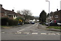
1
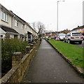
Maendy Way pavement, Upper Cwmbran
South of the Mynydd Maen Road junction the houses and pavement
on the east side of Maendy Way are slightly below road level.
Image: © Jaggery
Taken: 29 Mar 2017
0.01 miles
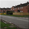
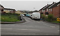
2
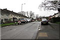
On-street parking, Maendy Way, Upper Cwmbran
Maendy Way south of the Mynydd Maen Road junction.
Image: © Jaggery
Taken: 29 Mar 2017
0.02 miles
3
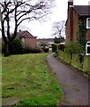
Path from Maendy Way to Maendy Place, Cwmbran
From the east side of Maendy Way.
Image: © Jaggery
Taken: 29 Mar 2017
0.02 miles
4
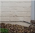
Ordnance Survey Cut Mark
This OS cut mark can be found on No1 Heol Newydd. It marks a point 136.602m above mean sea level.
Image: © Adrian Dust
Taken: 17 Aug 2020
0.04 miles
5
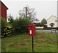
Queen Elizabeth II postbox on an Upper Cwmbran corner
Located on the right here, http://www.geograph.org.uk/photo/5329366 on the corner of Mynydd Maen Road and Maendy Way.
Image: © Jaggery
Taken: 29 Mar 2017
0.04 miles
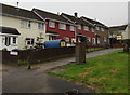
6
Wooden fence and brick houses, Maendy Way, Cwmbran
On the west side of Maendy Way.
Image: © Jaggery
Taken: 29 Mar 2017
0.04 miles
7
Mynydd Maen Road, Upper Cwmbran
Houses on the north side of Mynydd Maen Road, between Maendy Way and the Ysgol Place junction (ahead).
Image: © Jaggery
Taken: 29 Mar 2017
0.05 miles
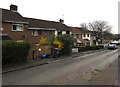
8
Heol Newydd houses, Upper Cwmbran
On the west side of Maendy Way, opposite the Mynydd Maen Road junction.
Image: © Jaggery
Taken: 29 Mar 2017
0.05 miles
9
Mynydd Maen Road, Upper Cwmbran
Descending from the east side of Maendy Way.
Image: © Jaggery
Taken: 29 Mar 2017
0.05 miles
10
Western arm of Maendy Way, Cwmbran
At right angles to the main course of Maendy Road, this road leads to Greenwood Avenue.
Image: © Jaggery
Taken: 29 Mar 2017
0.05 miles