IMAGES TAKEN NEAR TO
Alba Avenue, NP44 1FS
Introduction
This page details the photographs taken nearby to Alba Avenue, NP44 1FS by members of the Geograph project.
The Geograph project started in 2005 with the aim of publishing, organising and preserving representative images for every square kilometre of Great Britain, Ireland and the Isle of Man.

There are currently over 7.5m images from over14,400 individuals and you can help contribute to the project by visiting https://www.geograph.org.uk
Image Map
Images are licensed for reuse under creativecommons.org/licenses/by-sa/2.0
Notes
- Clicking on the map will re-center to the selected point.
- The higher the marker number, the further away the image location is from the centre of the postcode.
Image Listing (82 Images Found)
Images are licensed for reuse under creativecommons.org/licenses/by-sa/2.0
Image
Details
Distance
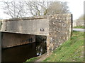
1
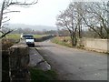
Across canal bridge 46, Sebastopol
Bevan's Lane crosses the bridge over the disused Monmouthshire & Brecon canal.
Image: © Jaggery
Taken: 26 Mar 2011
0.03 miles
2
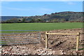
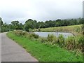
Field west of former Bridge 46, Bevan's Lane
This green field is scheduled to become part of the Edlogan Wharf housing estate. The hill in the background, right, is Mynydd Twyn-glas.
Image: © M J Roscoe
Taken: 12 Apr 2019
0.05 miles
3
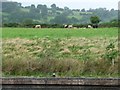
Cattle alongside South Sebastopol moorings
On the west bank of the Mon & Brec canal.
Image: © Christine Johnstone
Taken: 15 Sep 2013
0.05 miles
4
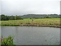
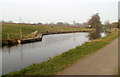
South Sebastopol moorings, Mon & Brec canal
Officially opened in August 2008, to encourage boaters to explore south of Pontymoile. Boats can go as far as Cwmbran Five Locks, walkers and cyclists all the way to Newport.
Image: © Christine Johnstone
Taken: 15 Sep 2013
0.08 miles
5
South Sebastopol moorings, from the north
Officially opened in August 2008, to encourage boaters to explore south of Pontymoile.
Image: © Christine Johnstone
Taken: 15 Sep 2013
0.08 miles
6
Disused Monmouthshire & Brecon canal south of Bevan's Lane, Sebastopol
Looking NNE in the direction of bridge 46 at Bevan's Lane.
Image: © Jaggery
Taken: 26 Mar 2011
0.09 miles
7
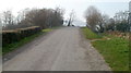
Bevan's Lane climbs towards canal bridge 46, Sebastopol
Bridge 46 http://www.geograph.org.uk/photo/2789096 carries the road over the disused Monmouthshire & Brecon canal.
Image: © Jaggery
Taken: 26 Mar 2011
0.09 miles
8
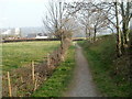
Track alongside Bevan's Lane, Sebastopol
A 50-metre long track runs from the edge of the disused Monmouthshire & Brecon canal (behind the camera). Ahead, it curves to the right to join Bevan's Lane.
Image: © Jaggery
Taken: 26 Mar 2011
0.09 miles
9
South side of canal bridge 46, Sebastopol
The bridge carries Bevan's Lane over the disused Monmouthshire & Brecon canal.
A white on black Griffithstown and Sebastopol Community Project notice states
PLEASE TAKE YOUR LITTER HOME.
Image: © Jaggery
Taken: 26 Mar 2011
0.09 miles
10
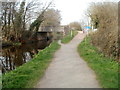
Approaching canal bridge 46 from the south, Sebastopol
Now used as a cycle route and footpath, the towpath alongside the disused Monmouthshire & Brecon canal approaches bridge 46. Bear left to go under the bridge, or straight ahead for Bevan's Lane.
Image: © Jaggery
Taken: 26 Mar 2011
0.09 miles