IMAGES TAKEN NEAR TO
Cwrt Carver, CWMBRAN, NP44 1FG
Introduction
This page details the photographs taken nearby to Cwrt Carver, NP44 1FG by members of the Geograph project.
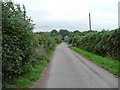
The Geograph project started in 2005 with the aim of publishing, organising and preserving representative images for every square kilometre of Great Britain, Ireland and the Isle of Man.

There are currently over 7.5m images from over14,400 individuals and you can help contribute to the project by visiting https://www.geograph.org.uk
Image Map
Images are licensed for reuse under creativecommons.org/licenses/by-sa/2.0
Notes
- Clicking on the map will re-center to the selected point.
- The higher the marker number, the further away the image location is from the centre of the postcode.
Image Listing (133 Images Found)
Images are licensed for reuse under creativecommons.org/licenses/by-sa/2.0
Image
Details
Distance
1
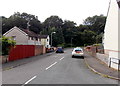
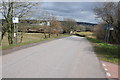
NE end of Berkeley Crescent, Sebastopol, Pontypool
Viewed across Lansdowne. The houses on the left are the only ones on this side of Berkeley Crescent. Ahead is the edge of a small wood surrounding an unnamed stream, a tiny tributary of the Afon Lwyd.
Image: © Jaggery
Taken: 9 Aug 2014
0.07 miles
2
Houses and trees, Berkeley Crescent, Sebastopol, Pontypool
For most of its 220 metre length, Berkeley Crescent has houses on only one side of the road.
The houses face a small wood surrounding an unnamed stream, a tiny tributary of the Afon Lwyd.
Image: © Jaggery
Taken: 9 Aug 2014
0.07 miles
3
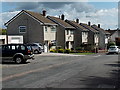
Zigzag row of houses in Berkeley Crescent, Sebastopol, Pontypool
Houses further from the camera are set progressively nearer the roadway and thus have progressively smaller front gardens.
Image: © Jaggery
Taken: 9 Aug 2014
0.07 miles
4
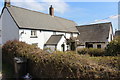
Farm house, Bevan's Lane, Sebastopol
Farm house and attached, apparently disused, outbuildings. All the farm will soon be in the middle of a housing estate.
Image: © M J Roscoe
Taken: 12 Apr 2019
0.08 miles
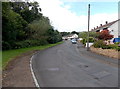
5
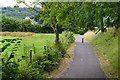
Bevan's Lane
Looking east from the canal bridge.
Image: © Christine Johnstone
Taken: 15 Sep 2013
0.08 miles
6
Road over the Monmouthshire and Brecon Canal
Minor road viewed from the bridge over the Monmouthshire and Brecon Canal near Sebastopol.
Image: © Philip Halling
Taken: 12 Apr 2013
0.09 miles
7
Path linking the canal with Bevan's Lane
Image: © David Martin
Taken: 18 Jul 2017
0.09 miles
8
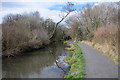
Tree reflected in the Monmouthshire and Brecon Canal
An inclined tree reflected in the Monmouthshire and Brecon Canal near Sebastopol.
Image: © Philip Halling
Taken: 12 Apr 2013
0.09 miles
9
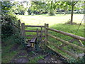
Stile at the southern end of Railway Terrace, Sebastopol
A few metres beyond the last house http://www.geograph.org.uk/photo/3087730 in Railway Terrace, a stile gives access to and from a field.
Image: © Jaggery
Taken: 18 Aug 2012
0.09 miles
10
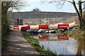
Coffer dam & bridge, Sebastopol
This wider bridge, on the Mon & Brec Canal, replaces Bridge 46 in order to carry traffic between large housing estates either side of the canal. NCR 49 has been diverted over the dam and rejoins the tow path via a dam on the far side of the bridge Image
Image: © M J Roscoe
Taken: 12 Apr 2019
0.09 miles