IMAGES TAKEN NEAR TO
Lon Gwenant, CWMBRAN, NP44 1FD
Introduction
This page details the photographs taken nearby to Lon Gwenant, NP44 1FD by members of the Geograph project.
The Geograph project started in 2005 with the aim of publishing, organising and preserving representative images for every square kilometre of Great Britain, Ireland and the Isle of Man.

There are currently over 7.5m images from over14,400 individuals and you can help contribute to the project by visiting https://www.geograph.org.uk
Image Map
Images are licensed for reuse under creativecommons.org/licenses/by-sa/2.0
Notes
- Clicking on the map will re-center to the selected point.
- The higher the marker number, the further away the image location is from the centre of the postcode.
Image Listing (89 Images Found)
Images are licensed for reuse under creativecommons.org/licenses/by-sa/2.0
Image
Details
Distance
1
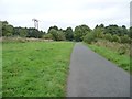
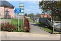
Cycle route along former railway line
Looking north, between Bevan's Lane and Sebastopol.
Image: © Christine Johnstone
Taken: 15 Sep 2013
0.04 miles
2
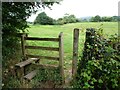
Footpath stile near Tir-brychiad
On the west side of the cycleway along the former railway line.
Image: © Christine Johnstone
Taken: 15 Sep 2013
0.06 miles
3
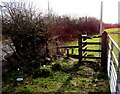
Stile to a public footpath, Sebastopol, Pontypool
From the west side of Avondale Road near Goshen Veterinary Centre. http://www.geograph.org.uk/photo/4321592
Image: © Jaggery
Taken: 24 Jan 2015
0.06 miles
4
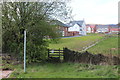
Stile next to NCR 492, Sebastopol
Wooden stile with 'footpath closed' sign next to new housing estate.
Image: © M J Roscoe
Taken: 12 Apr 2019
0.06 miles
5
Cycle track north from Bevan's Lane
NCR 492 here is on the course of a dismantled railway now running between housing estates under construction. The alignment of the track appears to have been modified, and the blue sign may be facing the wrong way.
Image: © M J Roscoe
Taken: 12 Apr 2019
0.07 miles
6
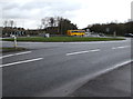
Grassy roundabout at the NE edge of Cwmbran
The 35 metres (115 ft) diameter roundabout is in the middle
of the junctions of the A4051, Avondale Road and Bevan's Lane.
Image: © Jaggery
Taken: 6 Mar 2019
0.08 miles
7
The Waterloo, Avondale Road, Pontypool
The Waterloo pub and restaurant is situated on Avondale Road,
at the southern edge of Pontypool (or perhaps the northern edge of Cwmbran).
UPDATE January 2015. The Waterloo has gone, replaced by Goshen Vets. http://www.geograph.org.uk/photo/4321592
Image: © Jaggery
Taken: 21 Oct 2009
0.08 miles
8
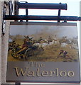
Pub sign, The Waterloo, Sebastopol
The Waterloo's http://www.geograph.org.uk/photo/1577025 sign is an artist's depiction of part of the Battle of Waterloo (1815).
Image: © Jaggery
Taken: 26 Mar 2011
0.08 miles
9
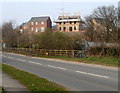
Parc Panteg, Griffithstown, Pontypool
Parc Panteg is a Persimmon development of 2- 3- and 4-bedroom houses built on the site of the demolished Panteg Steelworks. Viewed across Avondale Road.
Image: © Jaggery
Taken: 26 Mar 2011
0.08 miles
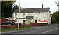
10
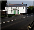
Goshen Veterinary Centre, Cwmbran
Goshen occupies the Avondale Road building that was previously The Waterloo. http://www.geograph.org.uk/photo/1577025 This location is either at the northern edge of Cwmbran or the southern edge of Sebastopol, Pontypool. There are no boundary signs nearby. Goshen gives its address as Cwmbran.
Image: © Jaggery
Taken: 24 Jan 2015
0.08 miles