IMAGES TAKEN NEAR TO
Parklawn Close, CWMBRAN, NP44 1ER
Introduction
This page details the photographs taken nearby to Parklawn Close, NP44 1ER by members of the Geograph project.
The Geograph project started in 2005 with the aim of publishing, organising and preserving representative images for every square kilometre of Great Britain, Ireland and the Isle of Man.

There are currently over 7.5m images from over14,400 individuals and you can help contribute to the project by visiting https://www.geograph.org.uk
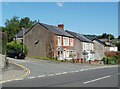
Image Map
Images are licensed for reuse under creativecommons.org/licenses/by-sa/2.0
Notes
- Clicking on the map will re-center to the selected point.
- The higher the marker number, the further away the image location is from the centre of the postcode.
Image Listing (329 Images Found)
Images are licensed for reuse under creativecommons.org/licenses/by-sa/2.0
Image
Details
Distance
1

Parklawn Close, Pontnewydd, Cwmbran
Dead-end street opposite Brooklands Terrace.
Image: © Jaggery
Taken: 20 Sep 2016
0.02 miles
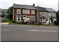
2
Corner of Lowlands Road and Parklawn Close, Pontnewydd, Cwmbran
The brownness of the ivy on the corner house in mid-July suggests that severe frosts around Christmas 2010 may have killed it.
Image: © Jaggery
Taken: 14 Jul 2011
0.03 miles
3
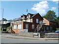
Pontnewydd Constitutional Club, Cwmbran
Located on the corner of Clark Avenue and Lowlands Road, adjacent to the War Memorial. http://www.geograph.org.uk/photo/2080286
Image: © Jaggery
Taken: 14 Jul 2011
0.03 miles
4
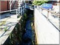
Blaen Bran brook, Lowlands Road, Pontnewydd, Cwmbran
Blaen Bran, a small tributary of the Afon Lwyd, flows towards the camera and Lowlands Road.
The footbridge connects Pontnewydd Constitutional Club http://www.geograph.org.uk/photo/2505398 on the left with a small car park.
Image: © Jaggery
Taken: 14 Jul 2011
0.03 miles
5

Lowlands Court, Pontnewydd, Cwmbran
Modern flats on the east side of Lowlands Road.
Image: © Jaggery
Taken: 23 Sep 2010
0.04 miles
6

Lowlands Road houses, Pontnewydd, Cwmbran
Houses at the southern end of Lowlands Road, on the corner of Park View.
Image: © Jaggery
Taken: 23 Sep 2010
0.04 miles
7

Clark Avenue Surgery, Pontnewydd, Cwmbran
Located near the Lowlands Road end of Clark Avenue. Pontnewydd Fire Station formerly occupied this site.
Image: © Jaggery
Taken: 23 Sep 2010
0.04 miles
8

Pontnewydd War Memorial, Cwmbran
Located at the junction of Lowlands Road and Clark Avenue.
Image: © Jaggery
Taken: 23 Sep 2010
0.04 miles
9
Lowlands Road semis, Pontnewydd, Cwmbran
The four Lowlands Road semi-detached houses are north of the Parklawn Close junction on the left.
Image: © Jaggery
Taken: 20 Sep 2016
0.05 miles
10
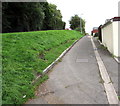
Up a canalside path, Pontnewydd, Cwmbran
From the corner of Richmond Close, the path ascends towards Richmond Place.
The disused Monmouthshire & Brecon Canal is below the bank on the left.
Image: © Jaggery
Taken: 20 Sep 2016
0.05 miles