IMAGES TAKEN NEAR TO
Richmond Road, CWMBRAN, NP44 1EQ
Introduction
This page details the photographs taken nearby to Richmond Road, NP44 1EQ by members of the Geograph project.
The Geograph project started in 2005 with the aim of publishing, organising and preserving representative images for every square kilometre of Great Britain, Ireland and the Isle of Man.

There are currently over 7.5m images from over14,400 individuals and you can help contribute to the project by visiting https://www.geograph.org.uk
Image Map
Images are licensed for reuse under creativecommons.org/licenses/by-sa/2.0
Notes
- Clicking on the map will re-center to the selected point.
- The higher the marker number, the further away the image location is from the centre of the postcode.
Image Listing (321 Images Found)
Images are licensed for reuse under creativecommons.org/licenses/by-sa/2.0
Image
Details
Distance
1
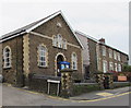
Richmond Road Baptist Church, Pontnewydd, Cwmbran
The church on the corner of Richmond Road and Richmond Place was built in 1882.
Image: © Jaggery
Taken: 20 Sep 2016
0.01 miles
2
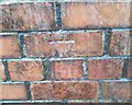
Ordnance Survey Cut Mark
This damaged OS cut mark can be found on the wall of the old Police Station site. It marks a point 83.512m above mean sea level.
Image: © Adrian Dust
Taken: 17 Aug 2020
0.01 miles
3
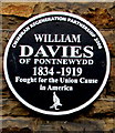
William Davies of Pontnewydd black plaque, Cwmbran
The Cwmbran Regeneration Partnership 2008 plaque is on the wall here. http://www.geograph.org.uk/photo/2080299
Image: © Jaggery
Taken: 20 Sep 2016
0.01 miles
4
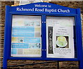
Information board outside Richmond Road Baptist Church, Pontnewydd, Cwmbran
On the left here. http://www.geograph.org.uk/photo/5130479 The board gives details of the religious and secular uses of the church and the nearby Chapel House.
Image: © Jaggery
Taken: 20 Sep 2016
0.01 miles
5
Lane from Richmond Close to Richmond Place, Pontnewydd, Cwmbran
Between the backs of Richmond Street houses (on the left) and Richmond Road houses.
Image: © Jaggery
Taken: 20 Sep 2016
0.01 miles
6
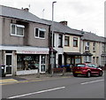
Cwmbran Angling shop, Pontnewydd, Cwmbran
Shop at 39 Richmond Road, opposite Richmond Road Baptist Church http://www.geograph.org.uk/photo/2080299
Image: © Jaggery
Taken: 20 Sep 2016
0.02 miles
7
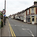
ILDIWCH/GIVE WAY sign facing Richmond Road, Pontnewydd, Cwmbran
The bilingual (Welsh/English) sign is at the Russell Street junction.
Class Cutz is on the right. http://www.geograph.org.uk/photo/2080309
Image: © Jaggery
Taken: 20 Sep 2016
0.03 miles
8
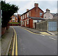
No parking in Russell Street, Pontnewydd, Cwmbran
Double yellow lines on both sides indicate no parking at any time.
Image: © Jaggery
Taken: 20 Sep 2016
0.03 miles
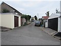
9
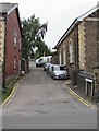
Up Richmond Place, Pontnewydd, Cwmbran
Richmond Place ascends from Richmond Road towards Richmond Street.
Richmond Road Baptist Church http://www.geograph.org.uk/photo/5130479 is on the right.
Image: © Jaggery
Taken: 20 Sep 2016
0.03 miles
10
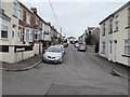
Richmond Street, Pontnewydd, Cwmbran
Richmond Street extends northwards for 70 metres from Richmond Close to Richmond Place.
Image: © Jaggery
Taken: 20 Sep 2016
0.04 miles