IMAGES TAKEN NEAR TO
Richmond Street, CWMBRAN, NP44 1EH
Introduction
This page details the photographs taken nearby to Richmond Street, NP44 1EH by members of the Geograph project.
The Geograph project started in 2005 with the aim of publishing, organising and preserving representative images for every square kilometre of Great Britain, Ireland and the Isle of Man.

There are currently over 7.5m images from over14,400 individuals and you can help contribute to the project by visiting https://www.geograph.org.uk
Image Map
Images are licensed for reuse under creativecommons.org/licenses/by-sa/2.0
Notes
- Clicking on the map will re-center to the selected point.
- The higher the marker number, the further away the image location is from the centre of the postcode.
Image Listing (334 Images Found)
Images are licensed for reuse under creativecommons.org/licenses/by-sa/2.0
Image
Details
Distance
1
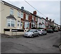
West side of Richmond Street, Pontnewydd, Cwmbran
The row of houses extends northwards for 70 metres from Richmond Close to Richmond Place.
Image: © Jaggery
Taken: 20 Sep 2016
0.02 miles
2
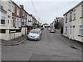
Richmond Street, Pontnewydd, Cwmbran
Richmond Street extends northwards for 70 metres from Richmond Close to Richmond Place.
Image: © Jaggery
Taken: 20 Sep 2016
0.02 miles
3
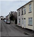
East side of Richmond Street, Pontnewydd, Cwmbran
Richmond Street extends northwards for 70 metres from Richmond Close to Richmond Place.
Image: © Jaggery
Taken: 20 Sep 2016
0.02 miles
4
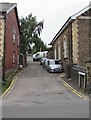
Up Richmond Place, Pontnewydd, Cwmbran
Richmond Place ascends from Richmond Road towards Richmond Street.
Richmond Road Baptist Church http://www.geograph.org.uk/photo/5130479 is on the right.
Image: © Jaggery
Taken: 20 Sep 2016
0.02 miles
5
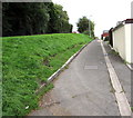
Up a canalside path, Pontnewydd, Cwmbran
From the corner of Richmond Close, the path ascends towards Richmond Place.
The disused Monmouthshire & Brecon Canal is below the bank on the left.
Image: © Jaggery
Taken: 20 Sep 2016
0.03 miles
6
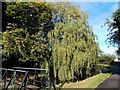
Canalside weeping willow, Pontnewydd,Cwmbran
Located by this http://www.geograph.org.uk/photo/2380240 footbridge, the middle tree is a weeping willow, scientific name Salix babylonica.
Image: © Jaggery
Taken: 4 Nov 2013
0.03 miles
7
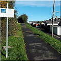
Canal towpath improvements notice, Pontnewydd,Cwmbran
The notice, in Welsh and English, gives information about improvements to the Pontnewydd section of the canal towpath, part of the disused southern section of the Monmouthshire & Brecon Canal, north of Commercial Street and Mount Pleasant Road.
Image: © Jaggery
Taken: 4 Nov 2013
0.03 miles
8

Richmond Road Baptist Church, Pontnewydd, Cwmbran
The church, on the corner of Richmond Road and Richmond Place, was built in 1882.
A black plaque http://www.geograph.org.uk/photo/5130505 on the wall at the right side of the doorway states
CWMBRAN REGENERATION PARTNERSHIP 2008
WILLIAM DAVIES OF PONTNEWYDD 1834-1919 Fought for the Union Cause in America.
Image: © Jaggery
Taken: 23 Sep 2010
0.03 miles
9
Cwmbran Angling, Pontnewydd, Cwmbran
Angling supplies shop located at 39 Richmond Road, viewed from Richmond Place.
Image: © Jaggery
Taken: 23 Sep 2010
0.03 miles
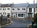
10
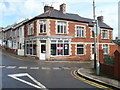
Classic Cutz, Pontnewydd, Cwmbran
Unisex salon and health & beauty are the words on display on the name panel.
Located on the corner of Richmond Road and Russell Street. A one-way system means that traffic approaching the camera from Richmond Road on the left must turn past the salon into Russell Street.
Image: © Jaggery
Taken: 23 Sep 2010
0.03 miles