IMAGES TAKEN NEAR TO
New Street, CWMBRAN, NP44 1EF
Introduction
This page details the photographs taken nearby to New Street, NP44 1EF by members of the Geograph project.
The Geograph project started in 2005 with the aim of publishing, organising and preserving representative images for every square kilometre of Great Britain, Ireland and the Isle of Man.

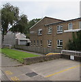
There are currently over 7.5m images from over14,400 individuals and you can help contribute to the project by visiting https://www.geograph.org.uk
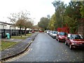
Image Map
Images are licensed for reuse under creativecommons.org/licenses/by-sa/2.0
Notes
- Clicking on the map will re-center to the selected point.
- The higher the marker number, the further away the image location is from the centre of the postcode.
Image Listing (329 Images Found)
Images are licensed for reuse under creativecommons.org/licenses/by-sa/2.0
Image
Details
Distance
1
Station Terrace, Pontnewydd, Cwmbran
The name is a reminder that close by was Upper Pontnewydd Station, on the original Monmouthshire Railway and Canal Company line, later known as the Eastern Valley Line. The station closed in the 1960s. Just beyond the right edge of the photo is Cwmbran Drive (A4051) which follows the route of the dismantled railway.
Image: © Jaggery
Taken: 23 Sep 2010
0.03 miles
2
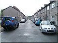
New Street, Pontnewydd, Cwmbran
The view from the northern end of the street, looking towards Russell Street.
Image: © Jaggery
Taken: 23 Sep 2010
0.03 miles
3
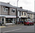
Cwmbran Angling shop, Pontnewydd, Cwmbran
Shop at 39 Richmond Road, opposite Richmond Road Baptist Church http://www.geograph.org.uk/photo/2080299
Image: © Jaggery
Taken: 20 Sep 2016
0.03 miles
4

Lane from Richmond Road to New Street, Pontnewydd, Cwmbran
This is not a through route for motor vehicles because there are three concrete
posts across the lane near the camera on the Richmond Road end of the lane.
Image: © Jaggery
Taken: 20 Sep 2016
0.03 miles
5
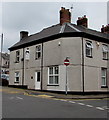
Edwards Dental Health Centre, Pontnewydd, Cwmbran
Dental surgery at 12 New Street on the corner of Russell Street.
Image: © Jaggery
Taken: 20 Sep 2016
0.03 miles
6
Brookland House, Pontnewydd, Cwmbran
The New Street side of Brookland House in Parklands Close. Managed by Bron Afon housing association, Brookland House is retirement/sheltered housing built in 1980.
Image: © Jaggery
Taken: 20 Sep 2016
0.04 miles
7
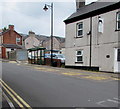
Russell Street bus stop and shelter, Pontnewydd, Cwmbran
This stop is for buses to Cwmbran town centre and bus station.
Image: © Jaggery
Taken: 20 Sep 2016
0.04 miles
8

Bus stop and shelter, Russell Street, Pontnewydd, Cwmbran
This stop is for buses to Cwmbran town centre and bus station.
Image: © Jaggery
Taken: 15 Feb 2019
0.04 miles
9
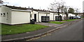
Station Terrace bungalows, Pontnewydd, Cwmbran
The name is a reminder that nearby was Upper Pontnewydd Station, on the original Monmouthshire Railway and Canal Company line, later known as the Eastern Valley Line. The station closed in the 1960s.
Image: © Jaggery
Taken: 20 Sep 2016
0.04 miles
10
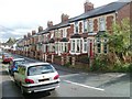
Brooklands Terrace, Pontnewydd, Cwmbran
Houses on the south side of the street, viewed from Lowlands Road. The north side of the street is the edge of a small park. Several maps I've consulted all agree in the spelling Brookland, whereas the street name sign seen here above the red door, and local references such as estate agents' adverts, use Brooklands.
Image: © Jaggery
Taken: 23 Sep 2010
0.04 miles