IMAGES TAKEN NEAR TO
Station Terrace, CWMBRAN, NP44 1DX
Introduction
This page details the photographs taken nearby to Station Terrace, NP44 1DX by members of the Geograph project.
The Geograph project started in 2005 with the aim of publishing, organising and preserving representative images for every square kilometre of Great Britain, Ireland and the Isle of Man.

There are currently over 7.5m images from over14,400 individuals and you can help contribute to the project by visiting https://www.geograph.org.uk
Image Map
Images are licensed for reuse under creativecommons.org/licenses/by-sa/2.0
Notes
- Clicking on the map will re-center to the selected point.
- The higher the marker number, the further away the image location is from the centre of the postcode.
Image Listing (319 Images Found)
Images are licensed for reuse under creativecommons.org/licenses/by-sa/2.0
Image
Details
Distance
1
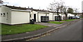
Station Terrace bungalows, Pontnewydd, Cwmbran
The name is a reminder that nearby was Upper Pontnewydd Station, on the original Monmouthshire Railway and Canal Company line, later known as the Eastern Valley Line. The station closed in the 1960s.
Image: © Jaggery
Taken: 20 Sep 2016
0.00 miles
2
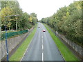
Cwmbran Drive heading north, Pontnewydd
The A4051 viewed from the Commercial Street/Station Road bridge. The road follows the route of the dismantled Eastern Valleys Railway.
Image: © Jaggery
Taken: 23 Sep 2010
0.03 miles
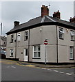
3
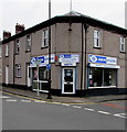
Jenkins Opticians, Pontnewydd, Cwmbran
At 13 New Street on the corner of Station Terrace.
Image: © Jaggery
Taken: 20 Sep 2016
0.03 miles
4
On-street parking, New Street, Pontnewydd, Cwmbran
Looking south along New Street towards Commercial Street Pontnewydd.
Image: © Jaggery
Taken: 20 Sep 2016
0.03 miles
5

Jenkins Opticians, 13 New Street, Pontnewydd, Cwmbran
On the corner of Station Terrace.
Image: © Jaggery
Taken: 15 Feb 2019
0.03 miles
6
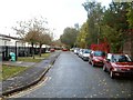
Station Terrace, Pontnewydd, Cwmbran
The name is a reminder that close by was Upper Pontnewydd Station, on the original Monmouthshire Railway and Canal Company line, later known as the Eastern Valley Line. The station closed in the 1960s. Just beyond the right edge of the photo is Cwmbran Drive (A4051) which follows the route of the dismantled railway.
Image: © Jaggery
Taken: 23 Sep 2010
0.04 miles
7
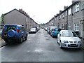
New Street, Pontnewydd, Cwmbran
The view from the northern end of the street, looking towards Russell Street.
Image: © Jaggery
Taken: 23 Sep 2010
0.04 miles
8
Edwards Dental Health Centre, Pontnewydd, Cwmbran
Dental surgery at 12 New Street on the corner of Russell Street.
Image: © Jaggery
Taken: 20 Sep 2016
0.04 miles
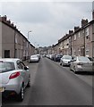
9
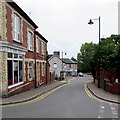
Russell Street, Pontnewydd, Cwmbran
From Richmond Road along Russell Street towards New Street and Station Terrace.
This is a one-way street. Direction of traffic is away from the camera.
Classic Cutz salon is on the left.
Image: © Jaggery
Taken: 20 Sep 2016
0.04 miles
10
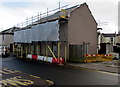
Scaffolding and sheeting on a Russell Street house, Pontnewydd, Cwmbran
Roofing work is in progress on the house on the corner of New Street in early March 2019.
Image: © Jaggery
Taken: 6 Mar 2019
0.04 miles