IMAGES TAKEN NEAR TO
Padarn Place, CWMBRAN, NP44 1DS
Introduction
This page details the photographs taken nearby to Padarn Place, NP44 1DS by members of the Geograph project.
The Geograph project started in 2005 with the aim of publishing, organising and preserving representative images for every square kilometre of Great Britain, Ireland and the Isle of Man.

There are currently over 7.5m images from over14,400 individuals and you can help contribute to the project by visiting https://www.geograph.org.uk
Image Map
Images are licensed for reuse under creativecommons.org/licenses/by-sa/2.0
Notes
- Clicking on the map will re-center to the selected point.
- The higher the marker number, the further away the image location is from the centre of the postcode.
Image Listing (334 Images Found)
Images are licensed for reuse under creativecommons.org/licenses/by-sa/2.0
Image
Details
Distance
1
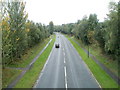
Cwmbran Drive heading south, Pontnewydd
The A4051 viewed from the Commercial Street/Station Road bridge. The road follows the route of the dismantled Eastern Valleys Railway.
Image: © Jaggery
Taken: 23 Sep 2010
0.02 miles
2

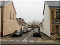
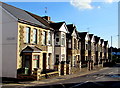
Row of houses, Chapel Street, Pontnewydd, Cwmbran
The middle of the row faces Cae-yr-Ebol. http://www.geograph.org.uk/photo/2327122
Image: © Jaggery
Taken: 26 Mar 2011
0.02 miles
3
Stanley Place, Pontnewydd, Cwmbran
Viewed from the corner of Chapel Street looking towards the perimeter wall of Cwmbran Drive (A4051).
Image: © Jaggery
Taken: 26 Mar 2011
0.02 miles
4
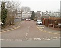
West along Padarn Place, Pontnewydd, Cwmbran
Padarn Place (Maes Padarn in Welsh) extends from Chapel Street to Laybourne Close.
Image: © Jaggery
Taken: 5 Oct 2016
0.02 miles
5
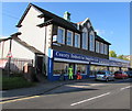
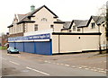
County Industrial Supplies, County House, Pontnewydd, Cwmbran
Viewed across Chapel Street. From a distance, I wondered why the two men were motionless.
Then I realised they're dummies displaying dayglo clothing.
Image: © Jaggery
Taken: 5 Oct 2016
0.03 miles
6
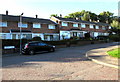
Laybourne Close houses, Pontnewydd, Cwmbran
Laybourne Close is on the west side of Chapel Street.
Image: © Jaggery
Taken: 5 Oct 2016
0.03 miles
7
Row of houses, Chapel Street, Pontnewydd, Cwmbran
Extending south for 40 metres from the corner of Stanley Place.
Image: © Jaggery
Taken: 5 Oct 2016
0.04 miles
8
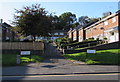
Cae-yr-Ebol, Pontnewydd, Cwmbran
Looking across Chapel Street towards housing on a cul-de-sac named Cae-yr-Ebol.
Image: © Jaggery
Taken: 26 Mar 2011
0.04 miles
9
County Industrial Supplies Ltd, Pontnewydd, Cwmbran
Location in County House, Chapel Street. The business is an accredited stockist of leading manufacturers for industry.
Despite research, I have not discovered the previous use of County House.
Image: © Jaggery
Taken: 26 Mar 2011
0.04 miles