IMAGES TAKEN NEAR TO
Crown Close, CWMBRAN, NP44 1BW
Introduction
This page details the photographs taken nearby to Crown Close, NP44 1BW by members of the Geograph project.
The Geograph project started in 2005 with the aim of publishing, organising and preserving representative images for every square kilometre of Great Britain, Ireland and the Isle of Man.

There are currently over 7.5m images from over14,400 individuals and you can help contribute to the project by visiting https://www.geograph.org.uk
Image Map
Images are licensed for reuse under creativecommons.org/licenses/by-sa/2.0
Notes
- Clicking on the map will re-center to the selected point.
- The higher the marker number, the further away the image location is from the centre of the postcode.
Image Listing (165 Images Found)
Images are licensed for reuse under creativecommons.org/licenses/by-sa/2.0
Image
Details
Distance
1
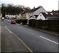
Houses on the west side of Meadowbrook Avenue, Cwmbran
From the south side of Five Locks Road, Meadowbrook Avenue leads to Crown Close and Glenside.
Image: © Jaggery
Taken: 6 Mar 2019
0.01 miles
2
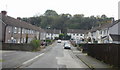
South along Meadowbrook Avenue, Cwmbran
From Five Locks Road, Meadowbrook Avenue leads to Crown Close and Glenside.
Image: © Jaggery
Taken: 6 Mar 2019
0.03 miles
3
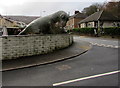
Alun the allosaurus on a Cwmbran corner
In the garden on the corner of Meadowbrook Avenue and Five Locks Road viewed on March 6th 2019. The 15ft tall depiction of an allosaurus formerly in the Dan yr Ogof Caves site was transported here last weekend by its new owner Jerry Adams. He bought it on eBay for £1,600. The purchase helped raise money for the diabetes charity JDRF UK.
Image: © Jaggery
Taken: 6 Mar 2019
0.05 miles
4
Meadowbrook Avenue, Pontnewydd, Cwmbran
Looking towards Crown Close http://www.geograph.org.uk/photo/1611990 from Five Locks Road.
Image: © Jaggery
Taken: 17 Oct 2009
0.05 miles
5
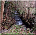
White water on Blaen Bran, Cwmbran
At 4pm on March 6th 2019, after many hours of rain in the previous 24 hours, the stream Blaen Bran flows vigorously away from Five Locks Road. Blaen Bran is a tributary of the Afon Lwyd.
Image: © Jaggery
Taken: 6 Mar 2019
0.05 miles
6
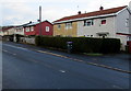
Metal-framed houses in Cwmbran
Viewed across the road named Ty Trappa in the north of Cwmbran.
Image: © Jaggery
Taken: 6 Mar 2019
0.05 miles
7
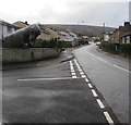
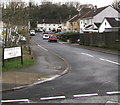
Junction of Five Locks Road and Meadowbrook Avenue, Cwmbran
Meadowbrook Avenue from the left joins Five Locks Road.
Alun the allosaurus https://www.geograph.org.uk/photo/6081874 is the garden on the corner.
Image: © Jaggery
Taken: 6 Mar 2019
0.05 miles
8
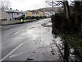
Surface water on Five Locks Road, Cwmbran
Viewed at 4pm on March 6th 2019 after many hours of rain
the previous night which continued into the morning.
Alun the allosaurus https://www.geograph.org.uk/photo/6081874 is in the background.
Image: © Jaggery
Taken: 6 Mar 2019
0.06 miles
9
Ordnance Survey Rivet
This OS rivet can be found on the culvert at the road junction. It marks a point 104.138m above mean sea level.
Image: © Adrian Dust
Taken: 17 Aug 2020
0.06 miles
10
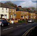
Five Locks Road semis, Cwmbran
Semi-detached houses on the north side of Five Locks Road in the north of Cwmbran.
Image: © Jaggery
Taken: 6 Mar 2019
0.06 miles