IMAGES TAKEN NEAR TO
Glenside, CWMBRAN, NP44 1BN
Introduction
This page details the photographs taken nearby to Glenside, NP44 1BN by members of the Geograph project.
The Geograph project started in 2005 with the aim of publishing, organising and preserving representative images for every square kilometre of Great Britain, Ireland and the Isle of Man.

There are currently over 7.5m images from over14,400 individuals and you can help contribute to the project by visiting https://www.geograph.org.uk
Image Map
Images are licensed for reuse under creativecommons.org/licenses/by-sa/2.0
Notes
- Clicking on the map will re-center to the selected point.
- The higher the marker number, the further away the image location is from the centre of the postcode.
Image Listing (193 Images Found)
Images are licensed for reuse under creativecommons.org/licenses/by-sa/2.0
Image
Details
Distance
1
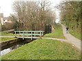
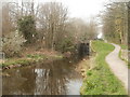
Canal bridge, Five Locks, Cwmbran
The footbridge crosses the disused Monmouthshire & Brecon canal between two of the five adjacent locks that give the area its name.
Image: © Jaggery
Taken: 26 Mar 2011
0.03 miles
2
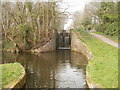
Canal lock south of Five Locks Road, Cwmbran
One of the five locks that give the adjacent road and area their names. Located on the disused Monmouthshire & Brecon canal.
Image: © Jaggery
Taken: 26 Mar 2011
0.03 miles
3
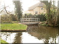
Canal footbridge near Beech Close, Cwmbran
The footbridge crosses an inlet of the former Monmouthshire & Brecon canal near one http://www.geograph.org.uk/photo/2451025 of five adjacent locks south of Five Locks Road. The house is on Beech Close.
Image: © Jaggery
Taken: 26 Mar 2011
0.03 miles
4
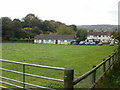
Glenside Community Centre, Cwmbran
Accessed via Five Locks Road, Meadowbrook Avenue then Crown Close, Glenside Community Centre is located on the western edge of the recreation area seen here. The photographer's location was a few metres from the Monmouthshire and Brecon canal.
Image: © Jaggery
Taken: 17 Oct 2009
0.04 miles
5

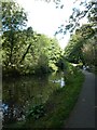
Glenside Community Centre, Cwmbran
Viewed across the former Monmouthshire & Brecon canal, from the towpath, now part of National Cycle Network route 46.
Image: © Jaggery
Taken: 26 Mar 2011
0.04 miles
6
One of the Five Locks, Cwmbran
Ahead is the southernmost of a group of five locks on the disused Monmouthshire & Brecon canal, south of Five Locks Road. A green footbridge http://www.geograph.org.uk/photo/2451003 can be glimpsed behind the lock.
Image: © Jaggery
Taken: 26 Mar 2011
0.04 miles
7
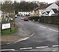
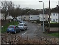
South along Meadowbrook Avenue, Cwmbran
From Five Locks Road, Meadowbrook Avenue leads to Crown Close and Glenside.
Image: © Jaggery
Taken: 6 Mar 2019
0.05 miles
8
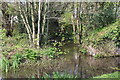
Tributary, Monmouthshire & Brecon Canal
Overflow from pond into canal below Five Locks.
Image: © M J Roscoe
Taken: 12 Apr 2019
0.05 miles
9
Walker by Monmouthshire and Brecon Canal in Pontnewydd
Image: © David Smith
Taken: 26 Sep 2021
0.06 miles
10
Beech Close, Cwmbran
Cul-de-sac on the southeast side of Five Locks Road.
Image: © Jaggery
Taken: 6 Mar 2019
0.06 miles