IMAGES TAKEN NEAR TO
Ty Trappa Road, CWMBRAN, NP44 1BH
Introduction
This page details the photographs taken nearby to Ty Trappa Road, NP44 1BH by members of the Geograph project.
The Geograph project started in 2005 with the aim of publishing, organising and preserving representative images for every square kilometre of Great Britain, Ireland and the Isle of Man.

There are currently over 7.5m images from over14,400 individuals and you can help contribute to the project by visiting https://www.geograph.org.uk
Image Map
Images are licensed for reuse under creativecommons.org/licenses/by-sa/2.0
Notes
- Clicking on the map will re-center to the selected point.
- The higher the marker number, the further away the image location is from the centre of the postcode.
Image Listing (143 Images Found)
Images are licensed for reuse under creativecommons.org/licenses/by-sa/2.0
Image
Details
Distance
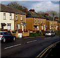
1
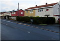
Metal-framed houses in Cwmbran
Viewed across the road named Ty Trappa in the north of Cwmbran.
Image: © Jaggery
Taken: 6 Mar 2019
0.01 miles
2
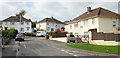
Crown Close, Cwmbran
Maps suggest this area of Cwmbran is called Lowlands, but local estate agents refer to Crown Close as part of Pontnewydd. Connected to Five Locks Road via Meadowbrook Avenue.
Image: © Jaggery
Taken: 17 Oct 2009
0.04 miles
3
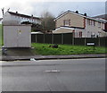
Western Power Distribution electricity substation, Ty Trappa, Cwmbran
The large cabinet is an electricity substation.
Its identifier is MOUNT PLEASANT PONTNEWYDD S/S 53-1887
The Ty Trappa name sign is on the right.
Image: © Jaggery
Taken: 6 Mar 2019
0.06 miles
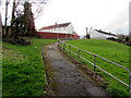
4
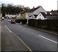
Houses on the west side of Meadowbrook Avenue, Cwmbran
From the south side of Five Locks Road, Meadowbrook Avenue leads to Crown Close and Glenside.
Image: © Jaggery
Taken: 6 Mar 2019
0.06 miles
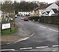
5
West along Mynydd Maen Road, Cwmbran
Viewed across Mount Pleasant Road.
Image: © Jaggery
Taken: 6 Mar 2019
0.06 miles
6
Path to Wentwood Close, Cwmbran
Ascending from Ty Trappa.
Image: © Jaggery
Taken: 6 Mar 2019
0.06 miles
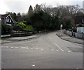
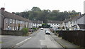
7
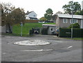
Ty Pwca / Ty Trappa / Five Locks mini-roundabout, Cwmbran
Perhaps the result of having been driven over, rather than around, many times, the bump in the road has an asymmetrical surface shape. This is the mini-roundabout at the junction of Five Locks Road, Ty Pwca Road, and Ty Trappa.
Image: © Jaggery
Taken: 17 Oct 2009
0.07 miles
8
South along Meadowbrook Avenue, Cwmbran
From Five Locks Road, Meadowbrook Avenue leads to Crown Close and Glenside.
Image: © Jaggery
Taken: 6 Mar 2019
0.07 miles
9
Five Locks Road semis, Cwmbran
Semi-detached houses on the north side of Five Locks Road in the north of Cwmbran.
Image: © Jaggery
Taken: 6 Mar 2019
0.07 miles
10
Meadowbrook Avenue, Pontnewydd, Cwmbran
Looking towards Crown Close http://www.geograph.org.uk/photo/1611990 from Five Locks Road.
Image: © Jaggery
Taken: 17 Oct 2009
0.07 miles