IMAGES TAKEN NEAR TO
Govilon Place, CWMBRAN, NP44 1AU
Introduction
This page details the photographs taken nearby to Govilon Place, NP44 1AU by members of the Geograph project.
The Geograph project started in 2005 with the aim of publishing, organising and preserving representative images for every square kilometre of Great Britain, Ireland and the Isle of Man.

There are currently over 7.5m images from over14,400 individuals and you can help contribute to the project by visiting https://www.geograph.org.uk
Image Map
Images are licensed for reuse under creativecommons.org/licenses/by-sa/2.0
Notes
- Clicking on the map will re-center to the selected point.
- The higher the marker number, the further away the image location is from the centre of the postcode.
Image Listing (229 Images Found)
Images are licensed for reuse under creativecommons.org/licenses/by-sa/2.0
Image
Details
Distance
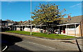
1
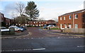
Govilon Place, Cwmbran
Cul-de-sac on the north side of Mount Pleasant Road.
Bilingual name signs show that Govilon Place is Maes Gofilon in Welsh.
Image: © Jaggery
Taken: 6 Mar 2019
0.01 miles
2
Mount Pleasant Road west of Church Road, Pontnewydd,Cwmbran
The grey electricity substation on the right faces Church Road.
Image: © Jaggery
Taken: 4 Nov 2013
0.03 miles
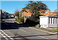
3
Gilwern Place, Cwmbran
Cul-de-sac on the north side of Mount Pleasant Road.
Image: © Jaggery
Taken: 6 Mar 2019
0.03 miles
4
Mount Pleasant Road bus stop and shelter, Cwmbran
This stop opposite Maindee Terrace is for buses to Cwmbran town centre and bus station.
Image: © Jaggery
Taken: 6 Mar 2019
0.04 miles
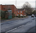
5
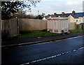
Electricity substation alongside Mount Pleasant Road, Cwmbran
The large cabinet is a Western Power Distribution electricity substation.
Its identifier is PARFITT TERRACE S/S 531918.
Image: © Jaggery
Taken: 6 Mar 2019
0.04 miles
6
Chimney pot variety, Mount Pleasant Road, Cwmbran
On houses on the approach to the Maindee Terrace junction.
Image: © Jaggery
Taken: 6 Mar 2019
0.04 miles
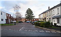
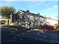
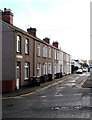
7
Parfitt Terrace, Cwmbran
Row of houses extending for 50 metres from the north side of Mount Pleasant Road.
The Welsh part of the bilingual name sign shows TERAS PARFITT.
Image: © Jaggery
Taken: 6 Mar 2019
0.05 miles
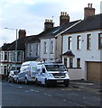
8
Parfitt Terrace, Pontnewydd,Cwmbran
A short row of houses viewed across Mount Pleasant Road.
Image: © Jaggery
Taken: 4 Nov 2013
0.05 miles
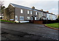
9
Houses on the south side of Mount Pleasant Close, Pontnewydd,Cwmbran
Viewed across Mount Pleasant Road. The houses in the background are in Parfitt Terrace. http://www.geograph.org.uk/photo/3730807
Image: © Jaggery
Taken: 4 Nov 2013
0.06 miles
10
Maindee Terrace, Cwmbran
Houses on the east side of Maindee Terrace viewed across Mount Pleasant Road.
Image: © Jaggery
Taken: 6 Mar 2019
0.06 miles