IMAGES TAKEN NEAR TO
NP4 2QH
Introduction
This page details the photographs taken nearby to NP4 2QH by members of the Geograph project.
The Geograph project started in 2005 with the aim of publishing, organising and preserving representative images for every square kilometre of Great Britain, Ireland and the Isle of Man.

There are currently over 7.5m images from over14,400 individuals and you can help contribute to the project by visiting https://www.geograph.org.uk
Image Map
Images are licensed for reuse under creativecommons.org/licenses/by-sa/2.0
Notes
- Clicking on the map will re-center to the selected point.
- The higher the marker number, the further away the image location is from the centre of the postcode.
Image Listing (7 Images Found)
Images are licensed for reuse under creativecommons.org/licenses/by-sa/2.0
Image
Details
Distance
1
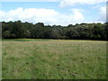
The edge of Cwm-heron Wood east of Croesyceiliog
Viewed from a field near Cwm-heron Farm. http://www.geograph.org.uk/photo/2601066
Image: © Jaggery
Taken: 13 Sep 2011
0.09 miles
2
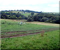
Looking towards and beyond Cwm-heron Wood
Viewed from a track to Cwm-heron Farm. The metal semi-circles are probably fodder
holders. Beyond Cwm-heron Wood is a glimpse of Church Farm and Hen Eglwys Farm.
Image: © Jaggery
Taken: 13 Sep 2011
0.09 miles
3
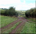
Track through a gap in a hedge near Cwm-heron Wood
Beyond a track junction, a muddy track continues towards Cwm-heron Farm and Cwm-heron Wood.
Image: © Jaggery
Taken: 13 Sep 2011
0.14 miles
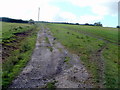
4
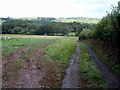
Parallel tracks descend towards Cwm-heron Wood
Ahead is Cwm-heron Wood. The tracks also lead to the entrance to Cwm-heron Farm, http://www.geograph.org.uk/photo/2601066 out of shot ahead.
Image: © Jaggery
Taken: 13 Sep 2011
0.14 miles
5
The climb away from the entrance track to Cwm-heron Farm
Viewed from near the farm entrance track. http://www.geograph.org.uk/photo/2601066
The way ahead leads to the Croesyceiliog Bypass (A4042), about 700 metres away.
Image: © Jaggery
Taken: 13 Sep 2011
0.14 miles
6
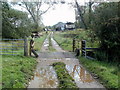
Entrance track to Cwm-heron Farm
Cwm-heron Farm is one of three farms located east of the A4042 and Croesyceiliog, west of Candwr Brook and south of Cwm-heron Wood.
Image: © Jaggery
Taken: 13 Sep 2011
0.14 miles
7
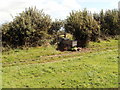
Water trough in a field near Cwm-heron Wood
The trough is located near a track through a gap in the hedge, just out of shot on the left. http://www.geograph.org.uk/photo/2601047
Image: © Jaggery
Taken: 13 Sep 2011
0.20 miles