IMAGES TAKEN NEAR TO
New Road, PONTYPOOL, NP4 0YW
Introduction
This page details the photographs taken nearby to New Road, NP4 0YW by members of the Geograph project.
The Geograph project started in 2005 with the aim of publishing, organising and preserving representative images for every square kilometre of Great Britain, Ireland and the Isle of Man.

There are currently over 7.5m images from over14,400 individuals and you can help contribute to the project by visiting https://www.geograph.org.uk
Image Map
Images are licensed for reuse under creativecommons.org/licenses/by-sa/2.0
Notes
- Clicking on the map will re-center to the selected point.
- The higher the marker number, the further away the image location is from the centre of the postcode.
Image Listing (91 Images Found)
Images are licensed for reuse under creativecommons.org/licenses/by-sa/2.0
Image
Details
Distance
1
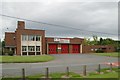
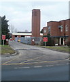
New Inn Fire Station
New Inn Fire Station, New Road, New Inn, Pontypool
Image: © Kevin Hale
Taken: 3 Jun 2007
0.01 miles
2
New Inn Fire Station
Located on the north side of New Road, part of the South Wales Fire & Rescue Service. The station opened in 1952.
Image: © Jaggery
Taken: 22 Jul 2018
0.01 miles
3
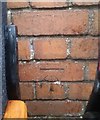
Ordnance Survey Cut Mark
This OS cut mark can be found on the Fire Training Tower. It marks a point 96.984m above mean sea level.
Image: © Adrian Dust
Taken: 19 Aug 2020
0.02 miles
4
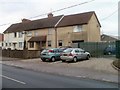
Holly View and Ivydene, New Road, Pontypool
Semi-detached houses on New Road, adjacent to the fire station. http://www.geograph.org.uk/photo/2245013
Image: © Jaggery
Taken: 21 Jan 2011
0.03 miles
5
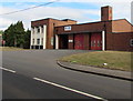
Training tower, New Inn fire station, Pontypool
Located at the western edge of the fire station http://www.geograph.org.uk/photo/2245013 on New Road, New Inn.
Image: © Jaggery
Taken: 21 Jan 2011
0.03 miles
6
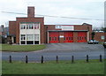
New Inn Fire Station, Pontypool
Part of the South Wales Fire & Rescue Service, New Inn Fire Station is located on the north side of New Road, between Panteg Way and Pont-y-felin Road. The station opened in 1952.
The uniformed staff total is 29 : 4 shifts or 'watches' of 7, plus the station manager. The areas normally covered include Pontypool (including Griffithstown, Sebastopol and New Inn) and the nearby areas around Little Mill and Penperlleni. New Inn crews are also deployed outside the area at times of major incidents, such as the summer 2007 major floods in South Yorkshire and the Gloucester area.
Image: © Jaggery
Taken: 21 Jan 2011
0.03 miles
7
East along New Road, New Inn
This way for New Inn Fire Station. https://www.geograph.org.uk/photo/5850412
Image: © Jaggery
Taken: 22 Jul 2018
0.04 miles
8

New Road bus stops, New Inn
Service number 18 is shown on the bus stop sign on the left. Viewed in July 2018 when no service 18 is shown on the Torfaen County Borough website's list of current bus services.
Image: © Jaggery
Taken: 22 Jul 2018
0.04 miles
9
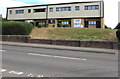
Jefflyn, New Road, New Inn
On the right, the office of Jefflyn Construction Ltd is in Unit 4, New Road.
Other names in view in July 2018 are Dylan's Dog Salon and Batch Plant.
Image: © Jaggery
Taken: 22 Jul 2018
0.05 miles
10
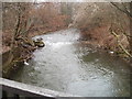
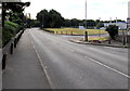
Afon Lwyd flows towards New Road, New Inn, Pontypool
The view upstream from the New Road bridge. http://www.geograph.org.uk/photo/2244939
Image: © Jaggery
Taken: 21 Jan 2011
0.05 miles