IMAGES TAKEN NEAR TO
Mamhilad Park Estate, PONTYPOOL, NP4 0XS
Introduction
This page details the photographs taken nearby to Mamhilad Park Estate, NP4 0XS by members of the Geograph project.
The Geograph project started in 2005 with the aim of publishing, organising and preserving representative images for every square kilometre of Great Britain, Ireland and the Isle of Man.

There are currently over 7.5m images from over14,400 individuals and you can help contribute to the project by visiting https://www.geograph.org.uk
Image Map
Images are licensed for reuse under creativecommons.org/licenses/by-sa/2.0
Notes
- Clicking on the map will re-center to the selected point.
- The higher the marker number, the further away the image location is from the centre of the postcode.
Image Listing (29 Images Found)
Images are licensed for reuse under creativecommons.org/licenses/by-sa/2.0
Image
Details
Distance
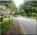
1
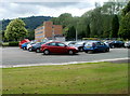
Car park for permit holders only, Mamhilad Park Estate
Viewed from Old Abergavenny Road. There is a visitors' car park http://www.geograph.org.uk/photo/3045844 on the opposite side of the road, located a little further than this one from premises in the estate.
Image: © Jaggery
Taken: 1 Jul 2011
0.05 miles
2
Office block at Mamhilad
These offices were built in the 1950's, as the style suggests, as part of the UK plant and head office of British Nylon Spinners, later to be subsumed within giant ICI, later becoming part of Du Pont and more recently I think being split into offices of the regional ambulance service, local authority etc.
Image: © Jeremy Bolwell
Taken: 25 Mar 2012
0.05 miles
3
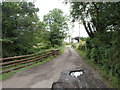
Residential access lane, Mamhilad
Viewed from Old Abergavenny Road.
The lane leads to two houses : Tilbach, 100 metres away, and Berthon House, 300 metres away.
The wall of a small stone bridge carrying the lane over an unnamed brook can be seen on the left, in a gap in the wooden fence.
Image: © Jaggery
Taken: 20 Jul 2012
0.08 miles
4
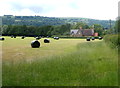
Field at the northern edge of Mamhilad Park Estate
Land use changes from business premises in Mamhilad Park Estate http://www.geograph.org.uk/photo/3045540 behind the camera to
agricultural ahead. In the distance is a Grade II listed former school. http://www.geograph.org.uk/photo/3046112
Image: © Jaggery
Taken: 1 Jul 2011
0.08 miles
5
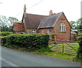
A view from the north of grade II listed Old School, Old Abergavenny Road, Mamhilad
SCHOOL 1856 is inscribed in stone above the doorway on the left.
Built in 1856 as Llanvihangel, Pontymoile and Mamhilad United District Board School for 90 children. Kelly's Directory of Monmouthshire, 1901 edition, records that the average attendance was 24.
Grade II listed in July 1997.
The school appears to have been closed for several years. Its current use, if any, is unknown to this contributor.
Image: © Jaggery
Taken: 20 Jul 2012
0.08 miles
6
1950's vintage office block at Mamhilad
Once the sales office of BNS (British Nylon Spinners).
Image: © Jeremy Bolwell
Taken: 25 Mar 2012
0.08 miles
7
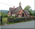
A view from the south of grade II listed Old School, Old Abergavenny Road, Mamhilad
SCHOOL 1856 is inscribed in stone above the doorway.
Built in 1856 as Llanvihangel, Pontymoile and Mamhilad United District Board School for 90 children. Kelly's Directory of Monmouthshire, 1901 edition, records that the average attendance was 24.
Grade II listed in July 1997.
The school appears to have been closed for several years. Its current use, if any, is unknown to this contributor.
Image: © Jaggery
Taken: 20 Jul 2012
0.08 miles
8
Visitors' car park, Mamhilad Park Estate
Located on the east side of Old Abergavenny Road. The car park for permit holders http://www.geograph.org.uk/photo/3045841 is on the opposite side of the road, a little nearer premises in the estate.
Image: © Jaggery
Taken: 1 Jul 2011
0.09 miles
9
Eastway, Mamhilad Park Estate
Internal road on industrial estate; the building on the left is Caerleon House.
Image: © M J Roscoe
Taken: 2 Mar 2021
0.10 miles
10
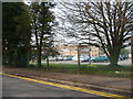
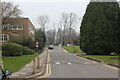
Southern section of Old Abergavenny Road, Mamhilad
This part of Old Abergavenny Road passes Mamhilad Park Estate on the left and Mamhilad Technology Park on the right. The main residential part of Mamhilad is nearly a kilometre ahead.
Image: © Jaggery
Taken: 1 Jul 2011
0.10 miles