IMAGES TAKEN NEAR TO
New Inn, PONTYPOOL, NP4 0XB
Introduction
This page details the photographs taken nearby to NP4 0XB by members of the Geograph project.
The Geograph project started in 2005 with the aim of publishing, organising and preserving representative images for every square kilometre of Great Britain, Ireland and the Isle of Man.

There are currently over 7.5m images from over14,400 individuals and you can help contribute to the project by visiting https://www.geograph.org.uk
Image Map
Images are licensed for reuse under creativecommons.org/licenses/by-sa/2.0
Notes
- Clicking on the map will re-center to the selected point.
- The higher the marker number, the further away the image location is from the centre of the postcode.
Image Listing (136 Images Found)
Images are licensed for reuse under creativecommons.org/licenses/by-sa/2.0
Image
Details
Distance
1
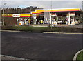
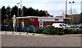
Shell filling station and car wash, Lower Mill Field, Pontypool
Viewed in late January 2015. A Google Earth Street View taken in June 2011 shows a Total filling station and car wash here.
Image: © Jaggery
Taken: 24 Jan 2015
0.01 miles
3
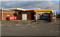
Soft Care car wash, Lower Mill Field, Pontypool
Part of a Shell garage. http://www.geograph.org.uk/photo/4325048
Image: © Jaggery
Taken: 24 Jan 2015
0.01 miles
4

Nolan Roadmarking van, Pontypool
Based in Seaway Parade Industrial Estate, Baglan, Port Talbot, Nolan Roadmarking works throughout the UK. This van is parked outside a Shell filling station in Lower Mill Field, Pontypool.
Image: © Jaggery
Taken: 24 Jan 2015
0.02 miles
5
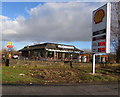
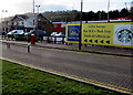
January 24th 2015 fuel prices in Pontypool
Viewed during a period of falling fuel prices which began in late 2014. This Shell filling station display shows 106.9 pence per litre for unleaded petrol and 115.9 pence per litre for diesel. McDonald's is in the background.
Image: © Jaggery
Taken: 24 Jan 2015
0.03 miles
6
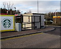
Starbucks logo and an electricity substation in Pontypool
The WE PROUDLY SERVE logo is the Starbucks Coffee Company brand, located alongside a cuboid box with ventilation slats housing a Western Power Distribution electricity substation located near KFC. http://www.geograph.org.uk/photo/4324157
Image: © Jaggery
Taken: 24 Jan 2015
0.03 miles
7
KFC Pontypool
Located near the Pontypool Metro Hotel. http://www.geograph.org.uk/photo/4324141 Originally named Kentucky Fried Chicken,
KFC is the second largest restaurant chain in the world (in terms of sales), after McDonald's.
Image: © Jaggery
Taken: 24 Jan 2015
0.04 miles
8
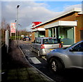
Work zone and coffee lounge this way, Pontypool
Arrows point left in Lower Mill Field. The We Proudly Serve logo on the right is a Starbucks Coffee Company brand. The Best Western Pontypool Metro Hotel http://www.geograph.org.uk/photo/4324141 is in the background.
Image: © Jaggery
Taken: 24 Jan 2015
0.04 miles
9
KFC Drive-Thru, Pontypool
The Drive-Thru is on the west side of this http://www.geograph.org.uk/photo/4324157 KFC. If you are too busy to park your car and walk into the KFC, you may get quicker service here, depending of course on the number of cars in front of you...
Image: © Jaggery
Taken: 24 Jan 2015
0.05 miles
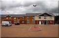
10
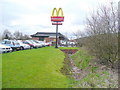
Fast food by the A4042
The restaurant is situated east of the roundabout with the A472 at Pontypool.
Image: © Jonathan Billinger
Taken: 7 Apr 2010
0.05 miles