IMAGES TAKEN NEAR TO
Jerusalem Lane, PONTYPOOL, NP4 0TT
Introduction
This page details the photographs taken nearby to Jerusalem Lane, NP4 0TT by members of the Geograph project.
The Geograph project started in 2005 with the aim of publishing, organising and preserving representative images for every square kilometre of Great Britain, Ireland and the Isle of Man.

There are currently over 7.5m images from over14,400 individuals and you can help contribute to the project by visiting https://www.geograph.org.uk
Image Map
Images are licensed for reuse under creativecommons.org/licenses/by-sa/2.0
Notes
- Clicking on the map will re-center to the selected point.
- The higher the marker number, the further away the image location is from the centre of the postcode.
Image Listing (125 Images Found)
Images are licensed for reuse under creativecommons.org/licenses/by-sa/2.0
Image
Details
Distance
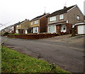
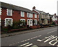
1
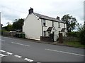
Pair of cottages, east side of Jerusalem Lane
Possibly now combined into one house.
Image: © Christine Johnstone
Taken: 13 Sep 2013
0.01 miles
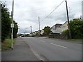
2
Jerusalem Lane, New Inn
Jerusalem Lane heads away from the junction with The Highway, Newport Road and Church Lane.
For about the next kilometre, Jerusalem Lane is a 2-lane suburban road, then it narrows to single track, to live up to its Lane name.
Image: © Jaggery
Taken: 17 Jan 2010
0.03 miles
3
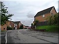
Houses in Jerusalem Close
On the west side of Jerusalem Lane.
Image: © Christine Johnstone
Taken: 13 Sep 2013
0.04 miles
4
Dunnet Gardens, New Inn
Houses on the south side of Dunnet Gardens, close to the junction with Jerusalem Lane.
Image: © Jaggery
Taken: 17 Jan 2010
0.05 miles
5
Houses above The Highway, New Inn
Numbered in The Highway sequence, these houses are alongside a side road above the east side of The Highway.
Image: © Jaggery
Taken: 12 Apr 2018
0.05 miles
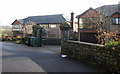
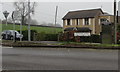
6
New Inn Care Home, The Highway, New Inn
Owned by Summerhill Care Homes Group.
Image: © Jaggery
Taken: 12 Apr 2018
0.05 miles
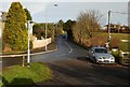
7
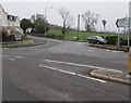
Junction at the southern end of Jerusalem Lane, New Inn
This junction is where Newport Road on the camera side
becomes The Highway to the left. The car is in Jerusalem Lane.
Image: © Jaggery
Taken: 12 Apr 2018
0.06 miles
8
BT phonebox, Newport Road, New Inn
Near the Jerusalem Lane junction.
Image: © Jaggery
Taken: 12 Apr 2018
0.07 miles
9
Housing variety in New Inn
Viewed across The Highway.
Image: © Jaggery
Taken: 12 Apr 2018
0.07 miles
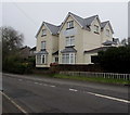
10
Detached houses, east side of Jerusalem Lane
The one with the bay windows was probably built in the 1930s, the other maybe in the 1970s.
Image: © Christine Johnstone
Taken: 13 Sep 2013
0.08 miles