IMAGES TAKEN NEAR TO
Newport Road, PONTYPOOL, NP4 0TP
Introduction
This page details the photographs taken nearby to Newport Road, NP4 0TP by members of the Geograph project.
The Geograph project started in 2005 with the aim of publishing, organising and preserving representative images for every square kilometre of Great Britain, Ireland and the Isle of Man.

There are currently over 7.5m images from over14,400 individuals and you can help contribute to the project by visiting https://www.geograph.org.uk
Image Map
Images are licensed for reuse under creativecommons.org/licenses/by-sa/2.0
Notes
- Clicking on the map will re-center to the selected point.
- The higher the marker number, the further away the image location is from the centre of the postcode.
Image Listing (7 Images Found)
Images are licensed for reuse under creativecommons.org/licenses/by-sa/2.0
Image
Details
Distance
1
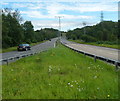
A4042 heads SE away from Lower New Inn
Viewed from the A4042/A4051 roundabout near the southern edge of Lower New Inn. The A4042 heads towards Croesyceiliog.
Image: © Jaggery
Taken: 18 Aug 2012
0.12 miles


4
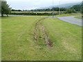
Short drainage channel near New Inn, Pontypool
The 40-metre long concrete-lined channel is on the side of Newport Road, a few tens of metres from the edge of residential New Inn. http://www.geograph.org.uk/photo/2474116 The channel ends at a culvert under the road ahead. http://www.geograph.org.uk/photo/2475081
Image: © Jaggery
Taken: 23 Jun 2011
0.21 miles
5
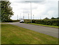
Old Newport Road near New Inn, Pontypool
Still shown on maps as Newport Road, this is now a lightly-trafficked road since the opening of the A4042. Most of the traffic using the road is to and from the Pimlico Furniture premises about 500 metres away.
Image: © Jaggery
Taken: 23 Jun 2011
0.21 miles
6
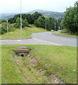
Unnamed road to the A4042 and A4051 near New Inn, Pontypool
Before the opening of the A4042, the left turn into Newport Road was the main road. Now most traffic continues ahead, down an unnamed road to the roundabout about 500 metres away, where the A4042 and A4051 meet.
A short drainage channel http://www.geograph.org.uk/photo/2474125 ends at a culvert under Newport Road. The New Inn boundary http://www.geograph.org.uk/photo/2475084 is a few tens of metres behind the camera.
Image: © Jaggery
Taken: 23 Jun 2011
0.21 miles
7
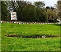
Coronation 2023 bunting near Newport Road, Lower New Inn, Torfaen
Set back from Newport Road, red, white and blue bunting celebrate the coronation
of King Charles III and Queen Camilla in Westminster Abbey on May 6th 2023.
A Pimlico Furniture direction sign is in the background.
Image: © Jaggery
Taken: 30 Apr 2023
0.25 miles