IMAGES TAKEN NEAR TO
Jerusalem Lane, PONTYPOOL, NP4 0TJ
Introduction
This page details the photographs taken nearby to Jerusalem Lane, NP4 0TJ by members of the Geograph project.
The Geograph project started in 2005 with the aim of publishing, organising and preserving representative images for every square kilometre of Great Britain, Ireland and the Isle of Man.

There are currently over 7.5m images from over14,400 individuals and you can help contribute to the project by visiting https://www.geograph.org.uk
Image Map
Images are licensed for reuse under creativecommons.org/licenses/by-sa/2.0
Notes
- Clicking on the map will re-center to the selected point.
- The higher the marker number, the further away the image location is from the centre of the postcode.
Image Listing (17 Images Found)
Images are licensed for reuse under creativecommons.org/licenses/by-sa/2.0
Image
Details
Distance
1
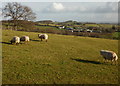
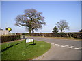
Grazing land, New Inn (2)
Grazing land adjacent to Jerusalem Lane. In the middle distance is Upper Trostra Farm.
Image: © Jaggery
Taken: 17 Jan 2010
0.15 miles
2
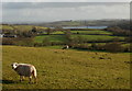
Grazing land, New Inn (1)
Grazing land adjacent to Jerusalem Lane. In the far distance is Llandegfedd Reservoir. http://www.geograph.org.uk/photo/21850
Image: © Jaggery
Taken: 17 Jan 2010
0.15 miles
3
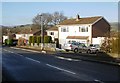
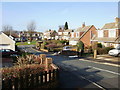
Golf Road houses adjacent to Jerusalem Lane, New Inn
Houses opposite Grosmont Road on the north side of Golf Road, near to its eastern end at Jerusalem Lane.
Image: © Jaggery
Taken: 17 Jan 2010
0.19 miles
4
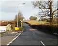
Junction of Jerusalem Lane and Chester Close, New Inn
Beyond the Chester Close junction, Jerusalem Lane narrows from a 2-lane suburban road into a 1-lane country road, and the 30 mph speed limit ends.
Image: © Jaggery
Taken: 17 Jan 2010
0.21 miles
5
Junction of Festival Crescent with Jerusalem Lane, New Inn
Image: © John Lord
Taken: 2 Mar 2011
0.22 miles
6
Hillcrest, New Inn
Looking from Jerusalem Lane along houses on Hillcrest towards Ambryn Road.
Image: © Jaggery
Taken: 17 Jan 2010
0.22 miles
7
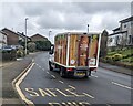
Sainsbury's home delivery van, New Inn, Torfaen
Ascending Golf Road on December 31st 2024.
Image: © Jaggery
Taken: 31 Dec 2024
0.24 miles
8

Snowman depiction, Golf Road, New Inn, Torfaen
At the edge of the green on the north side of Golf Road in December 2024.
A Nativity scene https://www.geograph.org.uk/photo/7950263 is nearby.
Image: © Jaggery
Taken: 31 Dec 2024
0.24 miles
9
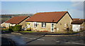
Chester Close, New Inn
Houses on the north side of Chester Close, near the Jerusalem Road junction.
Image: © Jaggery
Taken: 17 Jan 2010
0.24 miles
10
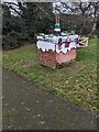
Christmas chimneystack depiction, New Inn, Torfaen
On the green on the north side of Golf Road in December 2024.
A Nativity scene https://www.geograph.org.uk/photo/7950263 is nearby.
Image: © Jaggery
Taken: 31 Dec 2024
0.24 miles