IMAGES TAKEN NEAR TO
Glascoed, PONTYPOOL, NP4 0TF
Introduction
This page details the photographs taken nearby to NP4 0TF by members of the Geograph project.
The Geograph project started in 2005 with the aim of publishing, organising and preserving representative images for every square kilometre of Great Britain, Ireland and the Isle of Man.

There are currently over 7.5m images from over14,400 individuals and you can help contribute to the project by visiting https://www.geograph.org.uk
Image Map
Images are licensed for reuse under creativecommons.org/licenses/by-sa/2.0
Notes
- Clicking on the map will re-center to the selected point.
- The higher the marker number, the further away the image location is from the centre of the postcode.
Image Listing (10 Images Found)
Images are licensed for reuse under creativecommons.org/licenses/by-sa/2.0
Image
Details
Distance
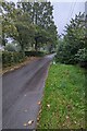
1
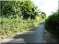
Glascoed Lane, looking east
At the 106 metre spot height.
Image: © Christine Johnstone
Taken: 13 Sep 2013
0.08 miles
2
Coed-Chambers Road, Glascoed, Monmouthshire
Looking to the ESE along Coed-Chambers Road from the edge of crossroads.
Image: © Jaggery
Taken: 17 Oct 2021
0.17 miles
3

Signpost at crossroads in Glascoed, Monmouthshire
Right for New Inn and Pontypool, left for Coed-y-Paen, behind the camera for Llanbadoc and Usk.
Image: © Jaggery
Taken: 17 Oct 2021
0.20 miles
4
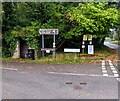
Golf course and chapel direction signs, Glascoed, Monmouthshire
The signs for a golf course (Cwrs Golff in Welsh) and Mount Zion Baptist Chapel are alongside Coed-Chambers Road near crossroads. A bus shelter and a litter bin are on the left.
Image: © Jaggery
Taken: 17 Oct 2021
0.20 miles
5
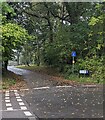
Dead-end School Road, Glascoed, Monmouthshire
School Road is on the south side of crossroads.
Image: © Jaggery
Taken: 17 Oct 2021
0.20 miles
6
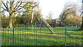
Playground in common land
Just south of the School House on Lower Common.
Image: © Jonathan Billinger
Taken: 3 Dec 2014
0.21 miles
7
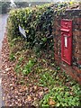
Victorian postbox, Glascoed, Monmouthshire
In a wall near crossroads.
Image: © Jaggery
Taken: 17 Oct 2021
0.21 miles
8
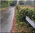
Bilingual lane name sign, Glascoed, Monmouthshire
The sign shows that Glascoed Lane is Lôn y Glascoed in Welsh.
Image: © Jaggery
Taken: 17 Oct 2021
0.22 miles
9
SSE along Wern Lane, Glascoed
Viewed from near this https://www.geograph.org.uk/photo/6994436 former red phonebox.
Image: © Jaggery
Taken: 17 Oct 2021
0.23 miles
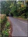
10
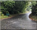
Road from Glascoed towards New Inn and Pontypool
Looking west from crossroads.
Image: © Jaggery
Taken: 17 Oct 2021
0.25 miles