IMAGES TAKEN NEAR TO
Coedypaen, PONTYPOOL, NP4 0TB
Introduction
This page details the photographs taken nearby to NP4 0TB by members of the Geograph project.
The Geograph project started in 2005 with the aim of publishing, organising and preserving representative images for every square kilometre of Great Britain, Ireland and the Isle of Man.

There are currently over 7.5m images from over14,400 individuals and you can help contribute to the project by visiting https://www.geograph.org.uk
Image Map
Images are licensed for reuse under creativecommons.org/licenses/by-sa/2.0
Notes
- Clicking on the map will re-center to the selected point.
- The higher the marker number, the further away the image location is from the centre of the postcode.
Image Listing (10 Images Found)
Images are licensed for reuse under creativecommons.org/licenses/by-sa/2.0
Image
Details
Distance
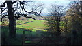
1
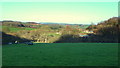
View over the Dowlais valley
From the stile on the lane below Craig y Saeson.
Image: © Jonathan Billinger
Taken: 3 Dec 2014
0.15 miles
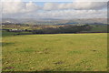
2
View to the Black Mountains
View to the Black Mountains from a footpath above Ty'n-y-caeau Wood. Clearly visible to the left of centre is the Sugar Loaf with Skirrid to the right.
Image: © Philip Halling
Taken: 12 Feb 2011
0.17 miles
3
View west from above Ty'n-y-caeau Wood
View west from above Ty'n-y-caeau Wood with the hills around Pontypool on the horizon.
Image: © Philip Halling
Taken: 12 Feb 2011
0.18 miles
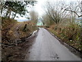
4
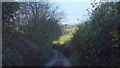
Dark deep lane
This road descends Craig y Saeson on its north scarp so hence is in deep shade on a winter afternoon.
The sunlit Dowlais valley can be seen beyond.
Image: © Jonathan Billinger
Taken: 3 Dec 2014
0.19 miles
5
View over the Dowlais valley
A gap in the wooded lane edge at Porth-llong.
Image: © Jonathan Billinger
Taken: 3 Dec 2014
0.22 miles
6
Track to Craig y Saeson
The track ascends from the road from Coed-y-Paen to Llangybi in rural Monmouthshire.
Craig y Saeson is a wood, a narrow eastward extension of a forest named The Forest.
Image: © Jaggery
Taken: 6 Feb 2012
0.22 miles
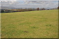
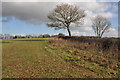
7
Grass-growing land
Soft green pastures of Monmouthshire.
Image: © Jonathan Billinger
Taken: 3 Dec 2014
0.22 miles
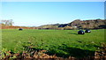
8
Farmland near Coed-y-Paen
From the footpath that follows this hedgerow there good views to the west.
Image: © Philip Halling
Taken: 12 Feb 2011
0.22 miles
9
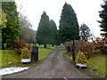
Tree-lined entrance to Forest House SE of Coed-y-Paen
Forest House is at the edge of a forest named The Forest.
Image: © Jaggery
Taken: 6 Feb 2012
0.24 miles
10
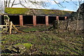
Farm building
Farm building beside a footpath between Llangibby Park and Coed-y-Paen.
Image: © Philip Halling
Taken: 12 Feb 2011
0.25 miles