IMAGES TAKEN NEAR TO
Coedypaen, PONTYPOOL, NP4 0SY
Introduction
This page details the photographs taken nearby to NP4 0SY by members of the Geograph project.
The Geograph project started in 2005 with the aim of publishing, organising and preserving representative images for every square kilometre of Great Britain, Ireland and the Isle of Man.

There are currently over 7.5m images from over14,400 individuals and you can help contribute to the project by visiting https://www.geograph.org.uk
Image Map
Images are licensed for reuse under creativecommons.org/licenses/by-sa/2.0
Notes
- Clicking on the map will re-center to the selected point.
- The higher the marker number, the further away the image location is from the centre of the postcode.
Image Listing (71 Images Found)
Images are licensed for reuse under creativecommons.org/licenses/by-sa/2.0
Image
Details
Distance
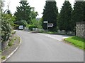
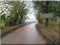
2
Road to Cwmbran from Coed-y-paen
A nearby sign shows 1 mile to Sôr Brook picnic area http://www.geograph.org.uk/photo/1751326, and 3 miles to Cwmbran.
Image: © Jaggery
Taken: 6 Feb 2012
0.04 miles
3
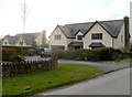
Wellfield Close houses, Coed-y-paen
In view are two of the three houses in Wellfield Close.
Image: © Jaggery
Taken: 6 Feb 2012
0.05 miles
4
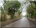
Western boundary of Coed-y-Paen
The road from Llandegfedd Reservoir reaches the boundary sign for
Coed-y-Paen, a small village in rural Monmouthshire.
Image: © Jaggery
Taken: 6 Feb 2012
0.07 miles
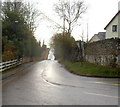
5
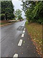
Road from Coed-y-paen to Llandegfedd Reservoir
The 30mph speed limit in Coed-y-paen increases to the National Speed Limit on the descent to Llandegfedd Reservoir.
Image: © Jaggery
Taken: 6 Feb 2012
0.08 miles
6
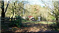
Equestrian dumping ground
On the edge of the village of Coed-y-Paen.
Image: © Jonathan Billinger
Taken: 3 Dec 2014
0.09 miles
7
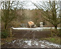
Disorderly collapsed lorry, Coed-y-paen
I was wondering how to describe the central feature of this view
when I found this in the 2011 Best Kept Village judges' comments:
"Disorderly collapsed lorry in field on edge of village"
Image: © Jaggery
Taken: 6 Feb 2012
0.09 miles
8
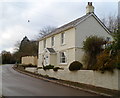
Wellfield House, Coed-y-paen
Located alongside the main road through the village, opposite a road junction.
Image: © Jaggery
Taken: 6 Feb 2012
0.10 miles
9
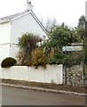
Old-style and new-style signs, Coed-y-paen
Located at the edge of Wellfield House. http://www.geograph.org.uk/photo/3127499
Above a modern sign pointing left towards Pontypool and Llandegfedd Reservoir
is a small old-style sign pointing left towards New Inn (3 miles).
Image: © Jaggery
Taken: 6 Feb 2012
0.10 miles
10
Road through Coed-y-Paen, Monmouthshire
Looking to the WSW from the edge of this https://www.geograph.org.uk/photo/6996497 junction.
Image: © Jaggery
Taken: 17 Oct 2021
0.10 miles