IMAGES TAKEN NEAR TO
Llandegfedd Way, PONTYPOOL, NP4 0RG
Introduction
This page details the photographs taken nearby to Llandegfedd Way, NP4 0RG by members of the Geograph project.
The Geograph project started in 2005 with the aim of publishing, organising and preserving representative images for every square kilometre of Great Britain, Ireland and the Isle of Man.

There are currently over 7.5m images from over14,400 individuals and you can help contribute to the project by visiting https://www.geograph.org.uk
Image Map
Images are licensed for reuse under creativecommons.org/licenses/by-sa/2.0
Notes
- Clicking on the map will re-center to the selected point.
- The higher the marker number, the further away the image location is from the centre of the postcode.
Image Listing (103 Images Found)
Images are licensed for reuse under creativecommons.org/licenses/by-sa/2.0
Image
Details
Distance
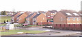
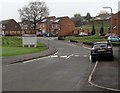
1

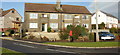
Llandegfedd Way side arm, New Inn
One of several side arms or branches diverging from the main route of Llandegfedd Way,
an area of houses on the NE side of The Highway, the main road through New Inn.
Image: © Jaggery
Taken: 12 Apr 2018
0.03 miles
2
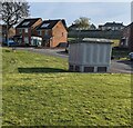
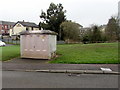
Cabinet and rooftop solar panels, New Inn, Torfaen
The cabinet is a Western Power Distribution electricity substation.
The solar panels are on the roof of Llandegfedd Way houses.
Image: © Jaggery
Taken: 3 Apr 2022
0.03 miles
3
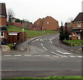
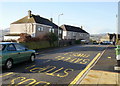
Towards speed bumps across Llandegfedd Way, New Inn
The speed bumps are across a side arm of Llandegfedd Way, an area of
houses on the NE side of The Highway, the main road through New Inn.
Image: © Jaggery
Taken: 12 Apr 2018
0.03 miles
4
Llandegfedd Way, New Inn
Viewed from The Highway
Image: © Jaggery
Taken: 17 Jan 2010
0.03 miles
6
Corner of Festival Crescent and Jerusalem Lane, New Inn
This is the southern edge of Festival Crescent where it joins Jerusalem Lane. Festival Crescent loops around the west of Jerusalem Lane and rejoins it about 250 metres northeast of here. http://www.geograph.org.uk/photo/1677200
Image: © Jaggery
Taken: 17 Jan 2010
0.04 miles
7
Festival Crescent, New Inn
Houses on the south side of Festival Crescent, close to its southern junction with
Jerusalem Lane. The crescent rejoins Jerusalem Lane about 250 metres north of this point.
Image: © Jaggery
Taken: 17 Jan 2010
0.04 miles
8
Teazer electricity substation, New Inn
The grey cabinet alongside Llandegfedd Way is a Western Power Distribution electricity substation.
Its identifier is TEAZER S/S 531343. The Teazer pub https://www.geograph.org.uk/photo/5736461 is in the background.
Image: © Jaggery
Taken: 12 Apr 2018
0.05 miles
9
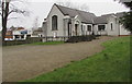
Panteg Methodist Church, New Inn
Part of the Gwent Hills and Vales Methodist Circuit.
Image: © Jaggery
Taken: 12 Apr 2018
0.05 miles
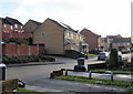
10
Speed bump across Llandegfedd Way, New Inn
Painted white triangles draw attention to the bump.
The grey cabinet is a Western Power Distribution electricity substation. https://www.geograph.org.uk/photo/5746024
Image: © Jaggery
Taken: 12 Apr 2018
0.05 miles