IMAGES TAKEN NEAR TO
New Road, PONTYPOOL, NP4 0PZ
Introduction
This page details the photographs taken nearby to New Road, NP4 0PZ by members of the Geograph project.
The Geograph project started in 2005 with the aim of publishing, organising and preserving representative images for every square kilometre of Great Britain, Ireland and the Isle of Man.

There are currently over 7.5m images from over14,400 individuals and you can help contribute to the project by visiting https://www.geograph.org.uk
Image Map
Images are licensed for reuse under creativecommons.org/licenses/by-sa/2.0
Notes
- Clicking on the map will re-center to the selected point.
- The higher the marker number, the further away the image location is from the centre of the postcode.
Image Listing (110 Images Found)
Images are licensed for reuse under creativecommons.org/licenses/by-sa/2.0
Image
Details
Distance
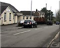
1
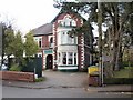
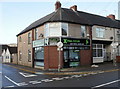
Greenlawn Social Club, New Inn
Located at 137 The Highway.
Image: © Jaggery
Taken: 17 Jan 2010
0.02 miles
2
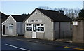
D.D.Racing, New Inn
A small, one-storey building at the southern edge of the Greenlawn Social Club http://www.geograph.org.uk/photo/1667579 car park
Image: © Jaggery
Taken: 17 Jan 2010
0.02 miles
3
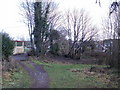
A designated public place, New Inn
Presumably once a problem area, this is now a designated public place in accordance with the Criminal Justice and Police Act 2001. http://www.geograph.org.uk/photo/1667605
Image: © Jaggery
Taken: 17 Jan 2010
0.02 miles
4
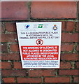
Designated public place notice, New Inn
The notice is on a wall alongside The Highway, New Inn. The designated public place is behind the wall. http://www.geograph.org.uk/photo/1667594
There is a misplaced apostrophe in the phrase
"a Police Officers' request"
Image: © Jaggery
Taken: 17 Jan 2010
0.02 miles
5
X-Trail Cycles, New Inn
On the corner of The Highway and New Road.
Image: © Jaggery
Taken: 17 Jan 2010
0.02 miles
6
New Road, New Inn
Buildings on the north side of New Road, viewed from the corner of The Highway.
Image: © Jaggery
Taken: 17 Jan 2010
0.02 miles
7
The Barber Shop, New Road, New Inn
The Barber Shop By Emma is located on New Road, close to the junction with The Highway.
Image: © Jaggery
Taken: 17 Jan 2010
0.02 miles
8
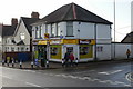
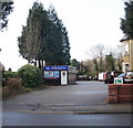
Highway Stores, New Inn
A Premier convenience store on the corner of The Highway and New Road.
Image: © Jaggery
Taken: 17 Jan 2010
0.02 miles
9
Down New Road, New Inn
New Road descends towards the valley of a river, the Afon Lwyd. New Inn Community Hall https://www.geograph.org.uk/photo/5748201 is on the left.
Image: © Jaggery
Taken: 12 Apr 2018
0.03 miles
10
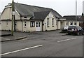
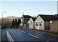
New Inn Community Hall, New Road, New Inn
Located 50 metres from the junction with The Highway, the main road through New Inn.
The building was previously Panteg Public Hall.
Image: © Jaggery
Taken: 12 Apr 2018
0.05 miles