IMAGES TAKEN NEAR TO
Prospect Place, PONTYPOOL, NP4 0PY
Introduction
This page details the photographs taken nearby to Prospect Place, NP4 0PY by members of the Geograph project.
The Geograph project started in 2005 with the aim of publishing, organising and preserving representative images for every square kilometre of Great Britain, Ireland and the Isle of Man.

There are currently over 7.5m images from over14,400 individuals and you can help contribute to the project by visiting https://www.geograph.org.uk
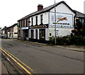
Image Map
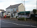
Images are licensed for reuse under creativecommons.org/licenses/by-sa/2.0
Notes
- Clicking on the map will re-center to the selected point.
- The higher the marker number, the further away the image location is from the centre of the postcode.
Image Listing (124 Images Found)
Images are licensed for reuse under creativecommons.org/licenses/by-sa/2.0
Image
Details
Distance
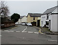
2
On-street parking, Woodfield Road, New Inn
On the east side of the road, opposite these bungalows. https://www.geograph.org.uk/photo/5736162
Image: © Jaggery
Taken: 12 Apr 2018
0.04 miles
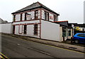
3
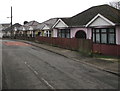
Woodfield Road bungalows, New Inn
Originally, bungalow was used in English for a lightly-built house, with a veranda and one storey.
In current UK usage it is a convenient word for any one-storey dwelling.
Image: © Jaggery
Taken: 12 Apr 2018
0.04 miles
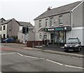
4
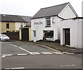
Ultimate Hair, Woodfield Road, New Inn
Hairdresser viewed across The Highway, the main road through New Inn.
Image: © Jaggery
Taken: 12 Apr 2018
0.05 miles
5
Junction of The Highway and Woodfield Road, New Inn
Viewed across The Highway, the main road through New Inn. Ultimate Hair https://www.geograph.org.uk/photo/5748220 is on the right.
Image: © Jaggery
Taken: 12 Apr 2018
0.05 miles
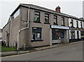
6
Aahar Indian Kitchen, 108 The Highway, New Inn
In April 2018, Aahar Indian cuisine restaurant is in premises formerly
occupied by the Rising Sun pub, seen here https://www.geograph.org.uk/photo/1670737 in January 2010.
Image: © Jaggery
Taken: 12 Apr 2018
0.05 miles
7
New Inn Pharmacy, 110 The Highway, New Inn
Viewed in April 2018. In January 2010, 110 The Highway was occupied by Panteg Post Office and Stores. https://www.geograph.org.uk/photo/1670669
Image: © Jaggery
Taken: 12 Apr 2018
0.05 miles
8
Cape Cod in New Inn
Cape Cod traditional fish & chips shop viewed across The Highway in April 2018.
New Inn Fish Bar https://www.geograph.org.uk/photo/1670715 was here in January 2010.
Image: © Jaggery
Taken: 12 Apr 2018
0.06 miles
9
New Inn Retro, 107A The Highway, New Inn
The shop sells retro toys, films etc. Names on the wall include Walkman, Polaroid and Nintendo.
Image: © Jaggery
Taken: 12 Apr 2018
0.06 miles
10
Panteg Post Office, New Inn
Panteg (rhymes with vague, not egg) is shown on maps as a distinct area to the east and south of New Inn, but even in central New Inn, there are references to Panteg, as here. This is Panteg Post Office and Stores, 110 The Highway, New Inn.
Image: © Jaggery
Taken: 17 Jan 2010
0.06 miles