IMAGES TAKEN NEAR TO
The Highway, PONTYPOOL, NP4 0PH
Introduction
This page details the photographs taken nearby to The Highway, NP4 0PH by members of the Geograph project.
The Geograph project started in 2005 with the aim of publishing, organising and preserving representative images for every square kilometre of Great Britain, Ireland and the Isle of Man.

There are currently over 7.5m images from over14,400 individuals and you can help contribute to the project by visiting https://www.geograph.org.uk
Image Map
Images are licensed for reuse under creativecommons.org/licenses/by-sa/2.0
Notes
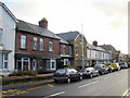
- Clicking on the map will re-center to the selected point.
- The higher the marker number, the further away the image location is from the centre of the postcode.
Image Listing (110 Images Found)
Images are licensed for reuse under creativecommons.org/licenses/by-sa/2.0
Image
Details
Distance
1
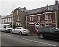
Woodland Cottage, The Highway, New Inn
The name between first floor windows on the house on the right is WOODLAND COTTAGE.
Image: © Jaggery
Taken: 12 Apr 2018
0.01 miles
2
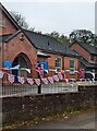
Coronation bunting on railings, New Inn
Viewed on April 30th 2023. This is a small part of a colourful display of
bunting extending for many metres on the west side of The Highway
in preparation for celebrations to mark the coronation of King Charles III
in Westminster Abbey on Saturday May 6th 2023.
Image: © Jaggery
Taken: 30 Apr 2023
0.02 miles
3
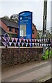
St Mary's Church Panteg Welcome Board
In April 2023 the church congregation meets in Panteg Church Hall set back from
The Highway in New Inn. The bunting is part of a colourful display extending
for many metres on the west side of The Highway in preparation for celebrations
to mark the coronation of King Charles III in Westminster Abbey on Saturday May 6th 2023.
Image: © Jaggery
Taken: 30 Apr 2023
0.03 miles
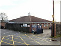
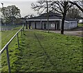
4
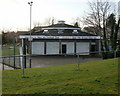
Pavilion, New Inn AFC
New Inn football club's pavilion, adjacent to the Golf Road football pitch. http://www.geograph.org.uk/photo/1667024
New Inn AFC play in Gwent County League Division 3 (season 2009/2010)
Image: © Jaggery
Taken: 17 Jan 2010
0.03 miles
5
1st Panteg (St Marys) Scout Group, New Inn
1st Panteg (St Marys) Scout Group, which includes Beavers Cub Scouts and Scouts, meet at the Church School building in New Inn, adjacent to The Highway.
Image: © Jaggery
Taken: 17 Jan 2010
0.03 miles
6
TOGs Centre, New Inn
Located on a short unnamed road between The Highway and a recreation ground.
The TOGs Family Centre provides services to families in Torfaen who have children or young people with physical, learning or sensory disabilities.
Image: © Jaggery
Taken: 17 Jan 2010
0.03 miles
7
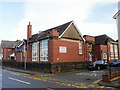
Family Learning Centre, New Inn
Located at The Old School, The Highway, New Inn.
The building was formerly New Inn Council School.
Image: © Jaggery
Taken: 17 Jan 2010
0.03 miles
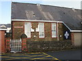
8
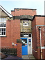
New Inn Family Learning Centre entrance
The New Inn Family Learning centre http://www.geograph.org.uk/photo/1667169 occupies the former New Inn Council School building. Relics of its past usage can be seen here. Between the 1907 and BOYS in the stone remnants is an old school bell.
Image: © Jaggery
Taken: 17 Jan 2010
0.03 miles
9
Housing variety, The Highway, New Inn
Houses on the east side of The Highway, between Golf Road and Woodfield Road.
Image: © Jaggery
Taken: 17 Jan 2010
0.03 miles
10
New Inn AFC clubhouse, Torfaen
The football club was established in 1936. In March 2024 the club website states
" Our First team play in Gwent County Division 1 and our reserve team play in Gwent Central division 1"
Image: © Jaggery
Taken: 31 Mar 2024
0.03 miles