IMAGES TAKEN NEAR TO
The Highway, PONTYPOOL, NP4 0PG
Introduction
This page details the photographs taken nearby to The Highway, NP4 0PG by members of the Geograph project.
The Geograph project started in 2005 with the aim of publishing, organising and preserving representative images for every square kilometre of Great Britain, Ireland and the Isle of Man.

There are currently over 7.5m images from over14,400 individuals and you can help contribute to the project by visiting https://www.geograph.org.uk
Image Map
Images are licensed for reuse under creativecommons.org/licenses/by-sa/2.0
Notes
- Clicking on the map will re-center to the selected point.
- The higher the marker number, the further away the image location is from the centre of the postcode.
Image Listing (112 Images Found)
Images are licensed for reuse under creativecommons.org/licenses/by-sa/2.0
Image
Details
Distance
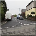
1
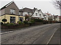
Houses alongside The Highway, New Inn
The houses are between two Ruth Road junctions, one of which is on the left. https://www.geograph.org.uk/photo/5735583
Image: © Jaggery
Taken: 11 Apr 2018
0.01 miles
2
Postbox on the corner of Ruth Road and The Highway, New Inn
The George V postbox is enclosed in an elegant brickwork arch.
Image: © Jaggery
Taken: 17 Jan 2010
0.03 miles
3
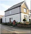
Ruth Road, New Inn
Houses on the east side of Ruth Road.
Image: © Jaggery
Taken: 17 Jan 2010
0.03 miles
4
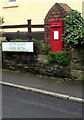
King George V postbox, Ruth Road, New Inn
Located on the right here https://www.geograph.org.uk/photo/5735583 near the corner of The Highway.
The GR on the box is short for Georgius Rex, Latin for King George,
in this case King George V who reigned from May 1910-January 1936
Image: © Jaggery
Taken: 11 Apr 2018
0.04 miles
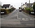
5
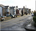
Junction of Ruth Road and The Highway, New Inn
The cars are in Ruth Road. This is one of two junctions of these roads.
The other one is https://www.geograph.org.uk/photo/5735607 180 metres to the southeast.
Image: © Jaggery
Taken: 11 Apr 2018
0.05 miles
6
Telecoms cabinets alongside The Highway, New Inn
The BT cabinet on the right is near a Virgin Media cabinet.
Image: © Jaggery
Taken: 11 Apr 2018
0.05 miles
7
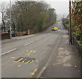
Northwestwards along The Highway, New Inn
The yellow car has just left Ruth Road. A speed camera sign is on the lamppost on the left.
Image: © Jaggery
Taken: 11 Apr 2018
0.07 miles
8
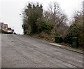
Up Ruth Road, New Inn
Ruth Road ascends from The Highway. This is one of two junctions of these roads.
The other one https://www.geograph.org.uk/photo/5735583 is 180 metres to northwest.
Image: © Jaggery
Taken: 11 Apr 2018
0.07 miles
9
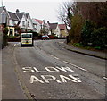
SLOW/ARAF on The Highway, New Inn
The English/Welsh text is on The Highway on the ascent towards the bend past the Ruth Road junction.
Image: © Jaggery
Taken: 11 Apr 2018
0.07 miles
10
The Avenue, New Inn
Private road and dead-end road viewed from the corner of The Highway.
The names The Avenue and The Highway suggest a time decades ago when
there may have been only one highway and one avenue in New Inn.
Image: © Jaggery
Taken: 11 Apr 2018
0.07 miles